

Elekistra, Patra, Achaea,West Greece
Castle of Elekistra
1
2 / 18

view from the east
3 / 18

west wall
4 / 18

the gate from the inside
5 / 18

lavatory
6 / 18

view from the north
7 / 18

photo Eugenia Tziava (2022)
8 / 18

photo Eugenia Tziava (2022)
9 / 18

photo Eugenia Tziava (2022)
10 / 18

photo Eugenia Tziava (2022)
11 / 18

photo K.Gertzos (2023)
12 / 18

photo K.Gertzos (2023)
13 / 18

photo K.Gertzos (2023)
14 / 18

photo K.Gertzos (2023)
15 / 18

photo K.Gertzos (2023)
16 / 18

photo K.Gertzos (2023)
17 / 18

photo K.Gertzos (2023)
18 / 18

view of the village from the west with the castle (right)

THE END
| Location: |
| At a slope 300m SW from the village Elekistra, east of Patras in Peloponnese |
| Region > Prefecture: |  |
| West Greece Achaea | |
| Municipality > Town: | |
| City of Patra • Elekistra | |
| Altitude: | |
|
Elevation ≈ 370 m (Relative Height≈30 m) |
| Time of Construction | Origin | |
| probably 13th cent. | FRANKISH |
|
| Castle Type | Condition | |
| Castle |
In Ruins
|
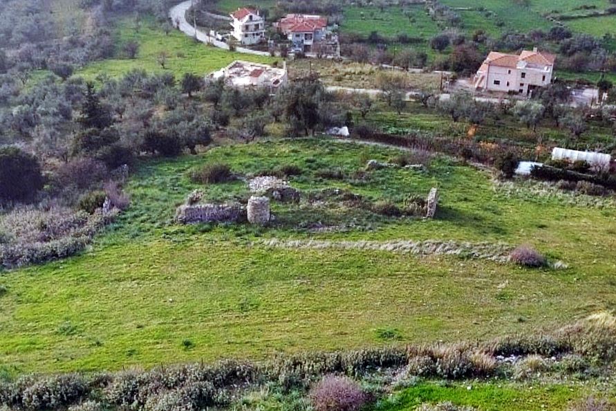
Ruins of a small Frankish castle outside, to the southwest, from the village of Elekistra, at the outskirts of Patras in Achaea. The location is on a slope at the foot of Mount Panahaikon without much natural protection, but with an unlimited view towards Patras and the plain of Patras.
History
Based on the history of the area and the construction features, the castle of Elekistra is Frankish. Logically, it belonged to one of the feudal lords of the Frankish barony of Patras. The barony of Patras, which was one of the 12 original baronies established in 1209 in the Principality of Achaea, had 24 fiefs. One of these fiefs was apparently in the area of Elekistra.
Being Frankish means it was built in the 13th or 14th century. The 15th century, a period of decline of the principality, should be excluded. The most likely period of construction is the first half of the 13th century, when the Principality of Achaea was in full rigor and the new masters of the Moreas, the Frankish crusaders, wanted to show off their newly acquired titles and secure the rights to their new land by creating castles and tower houses. Moreover, then it was a relatively peaceful period without serious external threats, and this would explain the not very strong construction of the castle and its rather vulnerable location.
However, the castle in Elekistra is not identified with certainty with any of the castles mentioned in the historical sources and in the lists of fiefs. Some scholars (Thomopoulos, Gerland) identify it with the fortress of Agios Elias (castrum Sancti Eliae) the existence of which is mentioned in the tables with the fiefs of 1377 and later of 1467 and 1469. It is also included in the lease contract made in 1408 by the Venetians with the Latin archdiocese of Patras, on the basis of which they took some castles in the area, and among them the castle of Agios Elias.
The problem is that the arguments for this identification are not serious. They rely on the fact that the name Elikistra begins with the same letters as Elias and on the other hand that no other castle ruins have been identified near Patras that could be the important fortress of Agios Elias. Equally arbitrary is the very far-fetched theory that "Elekistra" is etymologically derived from Elias+kisterna (i.e. Elias’ tank) which was corrupted into Elekistra.
Thus, we cannot accept the identification with the Fortress of Saint Elias (although it cannot be completely ruled out). More likely is the identification with another castle mentioned in Hopf's topographical catalogs of 1377 (dating correction from 1364) as Castello del Piano de Patrasso, i.e. castle of the Patras Plain. The reason for this assumption is that of the castles of the Patras region known to us today, the only one that controls a large part of the Patras plain is the castle of Elekistra.
On a map of the Expédition Scientifique de Morée of 1833, a “Venetian tower” called Le Kistra is marked at the location of the village. The name Lekistra, recorded then for the first time, obviously means “the castle” and from it came the current name Elekistra. But this does not shed more light on the question of the identification of the castle
Structure, Fortification & Buildings
The layout of the castle is rectangular. The area enclosed by the fortified enclosure is approximately 1500 sq.m.
The maximum surviving height of the walls is 3.5m. and the thickness of the walls is 0.70m. The relatively thin walls are reinforced internally and externally with struts.
In the construction, 3 building phases are observed, but they are not very far from each other. All are from the Frankish/Late-Byzantine period.
On the eastern wall, a gate formed by two strong 1m-thick pillars opens. which supports a semicircular arch. It is a simple arched opening, characteristic of Frankish fortified architecture. On the north side of the gate are the remains of a Γ-shaped staircase which led to the top of the wall.
Behind the gate, inside, there is a large semi-subterranean tank with a vaulted roof.
The interior yard is dominated by a cylindrical structure that is not a small tower but a toilet(!), which even has a “seat” at the point of defecation and openings for ventilation and lighting. The construction is similar to same-purpose facilities found in the castle of Mystras and belongs to the 3rd building phase, around the 15th century.
It is very likely that the surviving ruins were the inner enclosure of a larger castle; this conclusion is supported by:
1st) the extensive rock piles to the east, outside the castle,
2nd) the fact that the western wall seems to continue for at least 70 meters beyond the castle as there are traces of it on the slope of the dirt road,
3rd) the existence in an adjacent field of an old wall parallel to the western wall which may be the remains of an external enclosure.
| First entry in Kastrologos: | September 2022 |
Sources
- Anastasia Koumoussi, Nouveaux éléments concernantle réseau défensif franc en Achaïe, in Conference Proceedings «Δύμη: Φραγκοκρατία-Βενετοκρατία Α’-Τουρκοκρατία, 1-2 Οκτωβρίου 2005», Patras 2012
- photos 7-10 Eugenia Tziava (2022)
- ΑΡΧΑΙΟΛΟΓΙΚΟΝ ΔΕΛΤΙΟΝ. τεύχος 56-59/Β4. 2001-2004, σελ. 588
- Video and photos (11–18, July 2023) by Kostas Gertzos
|
|
| Access |
|---|
| Approach to the monument: |
| The village of Elekistra is 7km east of Patras. The castle is 300m from the church and easy to access. |
| Entrance: |
| Free access. |


