

Nasia, Kalavryta, Achaea,West Greece
Castle of Chotsa


| Location: |
| On the mountain above (to northwest) of the village Nasia in Kalavryta region of Achaea |
| Region > Prefecture: |  |
| West Greece Achaea | |
| Municipality > Town: | |
| City of Kalavryta • Nasia | |
| Altitude: | |
|
Elevation ≈ 830 m (Relative Height≈150 m) |
| Time of Construction | Origin | |
| perhaps 13th or 14th c. | FRANKISH |
|
| Castle Type | Condition | |
| Castle Ruins |
In Ruins
|
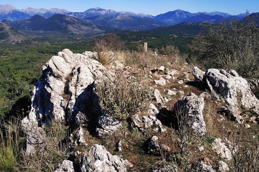
Ruins of a Frankish fortification, in the location “Chotsa” on the hill “Kastelli”. The hill belongs to the mountain range of Megali Rachi.
The site is in the region of Kalavryta, northwest of the village of Nasia and southeast of the village of Vesini.
It has visual contact with other similar fortifications in the reason: Avroti, Mamalouka, Strezova, Pefko.
History
We do not know details about the history of the fortification. It is considered medieval and not ancient, because the rough wall construction is not so old and also because there are no sites and findings from antiquity around there. It is most likely to have been created during the Frankish period in the 13th or 14th century, like most of the neighboring fortifications of this type in the mountains of Kalavryta.
During the Frankokratia, it must have belonged to the Barony of Akova.
Interestingly, despite its name, the castle is much closer to Nasia than to Vesini. This was probably the original place of the medieval Vesini. The Venetian census of Grimani in 1700, records a Vesigni which must have been the fortified settlement in Chotsa.
Structure, Fortification & Buildings
The castle occupies the top of the conical hill, within a perimeter of about 150 meters. Its layout is rather narrow, extending to the SE-NW axis.
To the south and outside the fortification, on the hillside there are scattered ruins that seem to be remnants of a settlement mixed with rubble that have fallen from the main fortification.
The fortified elongated section of the castle at the top consists of two small plateaus separated by a large rock. At the northeastern end of the castle, where is the top of the hill (with the topographic column), there are foundations of a 3✖3 m building that must have been a tower. There are traces of other buildings near the tower.
The north-northwest side of the castle is above a cliff and therefore is not protected by fortification. There was a wall on the south-southeast side, which is a stone structure made of semi-finished stones without mortar, 1 meter thick. This wall is 70 meters long. It is ruined with a maximum preserved height of 1 meter.
| First entry in Kastrologos: | June 2020 |
Sources
- Research, photographs and info by Sakis Lemonakis and his blog ΑΜΦΙΤΡΕΙΔΗΣ
- Konstantinos Kourelis, “MONUMENTS OF RURAL ARCHAEOLOGY MEDIEVAL SETTLEMENTS ΙΝ ΤΗΕ NORTHWESTERN PELOPONNESE”, Presented to the Faculties of the University of Pennsylvania in Partial Fulfillment of the Requirements for the Degree of Doctor of Philosophy, 2003 —#21, page 257
- Γεωργία Ζ.Αλεξοπούλου, Συμβολή στην αρχαιολογία και τοπογραφία της Αζανίας (Βόρειας Αρκαδίας) Επαρχία Καλαβρύτων, Πανεπιστήμιο Θεσσαλίας. Σχολή Επιστημών του Ανθρώπου. Τμήμα Ιστορίας, Αρχαιολογίας και Κοινωνικής Ανθρωπολογίας, Πάτρα 2009, #3186, σελ.340
- Γεώργιος Παπανδρέου, Καλαβρυτινή επετηρίς: ήτοι πραγματεία περί της ιστορικής των Καλαβρύτων επαρχίας, Εκ του Τυπογραφείου Μιχαήλ Ι. Σαλιβέρου, Εν Αθήναις 1906, σελ. 202.
|
|
| Access |
|---|
| Approach to the monument: |
A difficult dirt road starts NE of Nasia. Continue on foot after a water tank.(35min) |
| Entrance: |
| Free access |


