

Kastelli, Kalavryta, Achaea,West Greece
Kastraki of Kastelli
1
2 / 13

house ruins - Amfitreidis, 2019
3 / 13

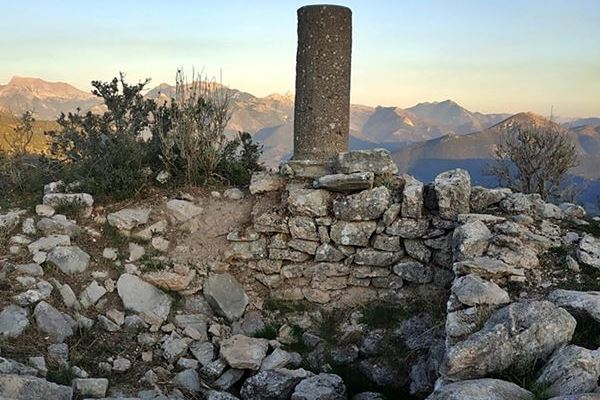
central tower - Amfitreidis, 2019
4 / 13

central tower - Amfitreidis, 2019
5 / 13

central tower - Amfitreidis, 2019
6 / 13

photo Amfitreidis, 2019
7 / 13

south wall - Amfitreidis, 2019
8 / 13

east wall - Amfitreidis, 2019
9 / 13

east wall and settlement ruins - Amfitreidis, 2019
10 / 13

east wall and settlement ruins - Amfitreidis, 2019
11 / 13

central tower - Amfitreidis, 2019
12 / 13

the hill of the castle - Amfitreidis, 2019
13 / 13

the opposite hill and castle of Ag. Theodoroi - Amfitreidis, 2019

THE END
| Location: |
| On a hill southeast of the village Kastelli of Achaea |
| Region > Prefecture: |  |
| West Greece Achaea | |
| Municipality > Town: | |
| City of Kalavryta • Kastelli | |
| Altitude: | |
|
Elevation ≈ 945 m (Relative Height≈60 m) |
| Time of Construction | Origin | |
| probably 13th or 14th c. | FRANKISH |
|
| Castle Type | Condition | |
| Castle Ruins |
In Ruins
|
Remains of a fortification on a hill, southeast of the village of Kastelli in the Kalavryta region.
On the opposite hill to the west, south of the village, at an air-distance of 850 meters from this castle, are the remains of another fortified settlement, in a similar condition, known as Agios Theodoros Castle.
History
In the lists of the fiefs of 1467 and 1471 there is a castle called Castelli. It is almost certain that the reference concerns one of the two castles in Kastelli, Achaea, or - most likely - both.
It is believed that the fortification belongs to the late Byzantine period and more specifically to the Frankokratia, a period during which various similar settlements developed in Frankish fiefs around and south of Kalavrita.
During the second period of the Venetian occupation, in the Grimani census of 1700, it is recorded as Castel Apano e Catu. Apparently those days, there was an Upper Castelli and a Lower Castellli. We do not know which of the two settlements on the two southern hills was the Upper Castelli, but the Lower one was at the place of the cemetery of the modern village. It was destroyed by Ibrahim pasha in the days of the Greek war of Independence.
Structure, Fortification & Buildings
In the middle of the fortress, an elevated plateau is formed on the SW-NE axis. At its highest point there are the foundations of a square tower measuring 3.5✖3.5m with a surviving height of 1 meter. Indications of waterproofing the foundations indicate that the ground floor of the tower housed a cistern (something very common). Five meters south of the tower, there are ruins of a rectangular building that may have been another water tank.
The perimeter wall of the fortress is 150 meters long and is built of irregularly shaped stones without mortar, with a maximum preserved height of 2 meters.
On the east side, inside the walls of the fortress, there are the ruins of a small settlement in two levels partitioned by an internal wall. At the southwestern end there are the remains of a single-space chapel. On the north side of the hill, outside the fort, there are successive plateaus formed by dry stone walls without traces of buildings.
| First entry in Kastrologos: | June 2020 |
Sources
- Research, photographs and info by Sakis Lemonakis and his blog ΑΜΦΙΤΡΕΙΔΗΣ
- Konstantinos Kourelis, “MONUMENTS OF RURAL ARCHAEOLOGY MEDIEVAL SETTLEMENTS ΙΝ ΤΗΕ NORTHWESTERN PELOPONNESE”, Presented to the Faculties of the University of Pennsylvania in Partial Fulfillment of the Requirements for the Degree of Doctor of Philosophy, 2003 — σελ. 288,289
- Γεωργία Ζ.Αλεξοπούλου, Συμβολή στην αρχαιολογία και τοπογραφία της Αζανίας (Βόρειας Αρκαδίας) Επαρχία Καλαβρύτων, Πανεπιστήμιο Θεσσαλίας. Σχολή Επιστημών του Ανθρώπου. Τμήμα Ιστορίας, Αρχαιολογίας και Κοινωνικής Ανθρωπολογίας, Πάτρα 2009, #157, page 214
|
|
| Access |
|---|
| Approach to the monument: |
| On the road Kalavryta-Tripoli, east of the village, we see the sign to “Kastelli”. Nearby there is a chapel of Evangelismos and a plateau where we leave the car. From there, 15min hike to the top. |
| Entrance: |
| Free access |


