

Amygdalia, Kalavryta, Achaea,West Greece
Castle of Mamalouka
or Castle of Amygdalia
1
2 / 11

ruins of the church - Amfitreidis, 2019
3 / 11

central tower - Amfitreidis, 2019
4 / 11

central tower - Amfitreidis, 2019
5 / 11

base of central tower - Amfitreidis, 2019
6 / 11

ruins of the church - Amfitreidis, 2019
7 / 11

photo Amfitreidis, 2019
8 / 11

rock before the tower - Amfitreidis, 2019
9 / 11

photo Amfitreidis, 2019
10 / 11

photo Amfitreidis, 2019
11 / 11

cistern remains - photo Amfitreidis, 2019

THE END
| Location: |
| On the mountain above (to the east) of the village Amygdalia in Kalavryta region of Achaea |
| Region > Prefecture: |  |
| West Greece Achaea | |
| Municipality > Town: | |
| City of Kalavryta • Amygdalia | |
| Altitude: | |
|
Elevation ≈ 1055 m (Relative Height≈220 m) |
| Time of Construction | Origin | |
| probably 13th or 14th c. | FRANKISH |
|
| Castle Type | Condition | |
| Castle Ruins |
In Ruins
|
Remains of a castle and a fortified settlement above the village of Amygdalia (former “Mamalouka”) in the region of Kalavryta. The location is on the elongated ridge of the hill of Agios Athanasios, which owes its name to a small church (now destroyed) located there, among the ruins of the castle.
The castle is at a high altitude, over 1000 meters and has a very good field of view. From the top, the valley of Ladonas is controlled, while it has visual contact with the city of ancient Kleitor and other castles in the area of Kalavryta: Sopotos, Strezova, Kastelli, Paos, Pefko, Chotsa etc.
History
We do not know details about the history of the fortification, which has not been identified with any castle known from the sources. The fortification is obviously medieval, judging by the masonry. It is most likely to have been created during the Frankokratia in the 13th or 14th century, like most of the neighboring fortifications of this type in the mountains south of Kalavryta.
During the Frankish occupation, it must have belonged to the Barony of Kalavryta.
However, it seems that the site was used in antiquity as well. In 1999, Professor G.A. Pikoulas discovered on the hill a Doric column capital and a fragment of a clay gutter that probably came from the ceramic decoration of a temple of the classical period. According to locals, occasionally other ancient artifacts have been found on this spot. It is believed that on the hill there was an ancient sanctuary which is partially covered today by the church of Agios Athanasios. It has been suggested that this sanctuary be identified with the temple of the Virgin Athena (Κορία Αθηνά) mentioned by Pausanias, a hypothesis that could be valid. Since there was an important ancient temple here, it would logically be protected by a fortification that would be part of the defensive system of the ancient Kleitor.
As mentioned above, the remains of the fortifications that can be seen today have medieval origins and are not related to the ancient fortifications that we assume existed there before.
Structure, Fortification & Buildings
The castle is built on the long narrow plateau of the peak, on the axis from SW to NE. It consists of two plateaus: a small fortress high with its own fortified enclosure and, at a lower level, the ruins of a small settlement.
The wall that encloses the fortress is preserved in ruins, but its trace is evident in a great length that reaches 130 meters. The original outer perimeter of the castle may have reached 200 meters.
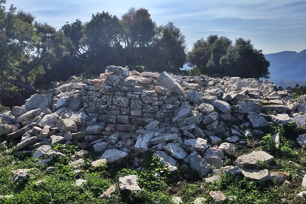
At the highest point, where the geodetic column is, there are the ruins of the central tower measuring 6✖6 meters, with the remains creating a 5 meter high stone pile covered with vegetation. Right next to it, to the south, are the ruins of a rectangular building that was probably a water tank.
On the north side of the castle and within the walls are the remains of the church of Agios Athanasios measuring 8✖6 m. The church was built on an ancient building, as concluded from its foundations consisting of large rectangular stones apparently of ancient Greek origin and from the retaining walls that consist of a similar ancient stone structure. Everything shows that there really was an important ancient construction here, probably a temple.
The ancient stones have been used as building material for other buildings as well, and are scattered throughout the area. Also to the south of the castle, on a plateau 4-5 meters lower, there is the area of the settlement, with unclear ruins of houses. At the extreme northeastern end, the plateau narrows and it is not clear where the fortification ends. Earlier researchers, such as Ballas (1997), hypothesized the existence of gates at this point, which cannot be verified. In the southern part the slope of the hill is smooth, but it has natural protection from a massive limestone rock, a few meters south of the central tower.
| First entry in Kastrologos: | June 2020 |
Sources
- Research, photographs and info by Sakis Lemonakis and his blog ΑΜΦΙΤΡΕΙΔΗΣ
- Konstantinos Kourelis, “MONUMENTS OF RURAL ARCHAEOLOGY MEDIEVAL SETTLEMENTS ΙΝ ΤΗΕ NORTHWESTERN PELOPONNESE”, Presented to the Faculties of the University of Pennsylvania in Partial Fulfillment of the Requirements for the Degree of Doctor of Philosophy, 2003 —#10, pag.244,245
- Γεωργία Ζ.Αλεξοπούλου, Συμβολή στην αρχαιολογία και τοπογραφία της Αζανίας (Βόρειας Αρκαδίας) Επαρχία Καλαβρύτων, Πανεπιστήμιο Θεσσαλίας. Σχολή Επιστημών του Ανθρώπου. Τμήμα Ιστορίας, Αρχαιολογίας και Κοινωνικής Ανθρωπολογίας, Πάτρα 2009, #277, pag.501
|
|
| Access |
|---|
| Approach to the monument: |
Take a dirt road 350m N of Amygdalia. After 350m turn right and continue for 200m. Then leave the car and continue on foot for 30min.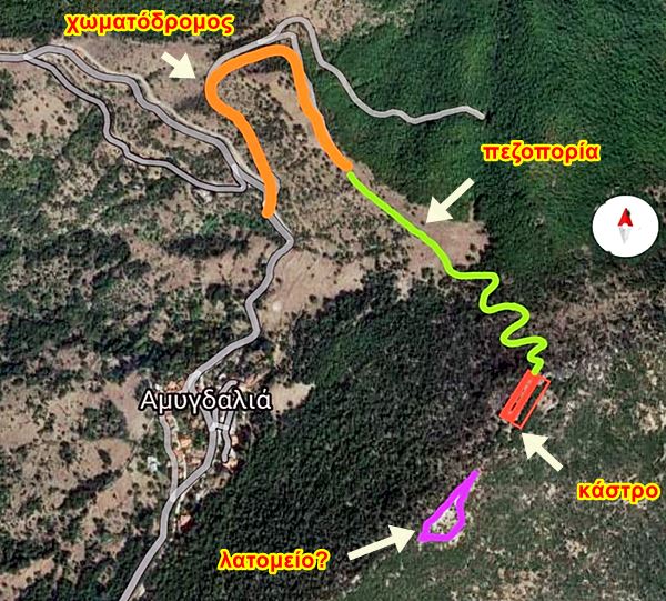 |
| Entrance: |
| Free access |


