

Grizano, Farkadona, Trikala,Thessaly
Castle of Grizano
or Castle of Oria or Grizos


| Location: |
| On a hill to the east and above the village of Grizano, near Trikala, Thessaly |
| Region > Prefecture: |  |
| Thessaly Trikala | |
| Municipality > Town: | |
| City of Farkadona • Grizano | |
| Altitude: | |
|
Elevation ≈ 445 m (Relative Height≈200 m) |
| Time of Construction | Origin | |
| probably 10th cent. | BYZANTINE |
|
| Castle Type | Condition | |
| Castle |
Not Good
|
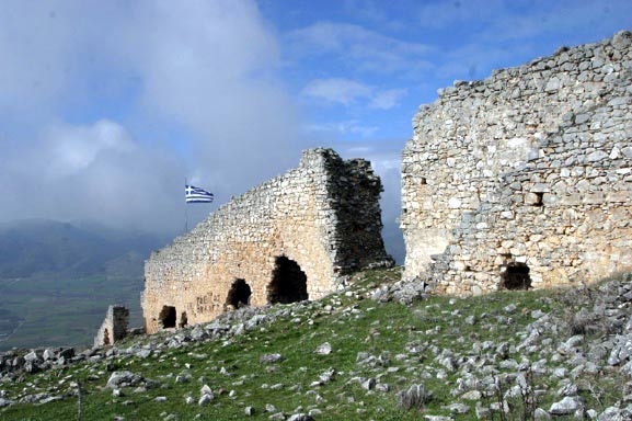
A ruined castle on the rocky hill ΝΕ of the village Grizano, north of Trikala in Thessaly.
It is one of the largest castles in mainland Greece enclosing a fortified area of almost 140,000 sq.m. This is an unusual size for the standards of the Byzantine or Frankish forts in Greece.
Judging from the lack of adequate references by historical sources and from the absence of visible remains in the interior, we conclude that this fortification has never been a significant settlement. Perhaps a small village, but not a medieval city (which would justify the extended fortification).
Location & Strategic Scope
The fortress guarded the passages from Ellasona and the lower Olympus mountain to Thessaly. This point, historically, was always on the borderline between West Thessaly and West Macedonia.
This is the reason why the area is scattered with small forts, remains of the period 1881-1912, when here was the frontiers between Greece and Turkey (the Grizano castle itself served as one of these 19th century guardposts).
The Name of the Castle
Obviously, the castle and the village took their name (which is of slavic origin) from the big, long gray rock where the castle is built.
During the Middle Byzantine period, its name was Tziviskon, while in a Norman chronicle of the same period is recorded as Cirisci.
History
It was built in the Middle Ages, but we do not known exactly when. The castle has never been researched nor excavated. It was not one of the fortresses built by emperor Justinian in the mid 6th century since it is not among the castles listed in Thessaly by the historian Procopius in his oeuvre De Aedificiis.
In the following centuries, 7th to 9th, Thessaly was flooded by invading Slav tribes and went through a dark period of oblivion and regression. No castle could have been built there, in those years.
Most probably, it was built in the first decades of the 10th century, around 930, when emperor Romanos I Lekapenos built several castles in Macedonia and Thessaly, in an effort to contain the Bulgarians who, in the previous years, under the leadership of Symeon I attempted to expand their territory to the south.
Another less probable theory is that the castle was built in the 11th century by some warlord of the Vlachs, a nomadic and occasionally warlike tribe, the presence of which is mentioned for the first time in 1075.
What we know for sure is that the castle was captured in 1082 by the Norman Bohemund during his campaign in Thessaly. Bohemund was defeated and repelled after a few months by the Byzantine emperor Alexios I Comnenos who rushed with his army in order to defend Larissa. It is worth mentioning that Boehenund became an important historical figure of the 11th century. He was the son of the Norman king of Sicily Robert Guiscard and in 1096 was one of the leaders (the most prominent) of the first Crusade. He later became “Prince of Antioch”.
The incident of the capture of the castle by Bohemund is mentioned by two sources: by the historian Anna Komnini in her book Alexias and by the French (or Italian) chronicler William of Apoulia (Guillaume de Pouille or Guglielmo di Puglia or Guillelmus Apuliensis) in his chronicle about the life of Robert Guiscard. Anna Komnini refers to the castle as “Tziviskos” and Willam as “Cirisci”. Grizano is generally identified with these names.
That was the only time that the castle is mentioned by historical sources. We never hear about it again, despite the fact that the history of the late-Byzantine Thessaly is eventful, with conflicts and frequent successions of overlords.
The absence of any references after the 11th century does not necessarily mean that the castle was not in use. But it is obvious that it never became a major settlement and it is very likely that it had been abandoned rather early, perhaps before the Ottoman conquest. During the Ottoman period (the Tourkokratia), it must have been already deserted. However, it must have been used as a refuge by the locals during raids, for a long time.
Structure, Fortification & Buildings
This is a large castle with a perimeter of exterior walls around 2000m enclosing a surface of 140,000 sq.meters. In the middle of the castle there is a transverse fortified wall separating the interior in two parts.
The wall structure is not very sophisticated but was strong enough. The northern side of the fortification is preserved in better condition than the rest, with a wall height reaching 7 to 8 meters. There were over 20 towers along the walls, some of which maintain a visible height.
The western side of the fortfication reached low, almost to the modern village boundaries, in order to include a water-spring. This part is also the most ruined being more accessible to the villagers who used materials from the castle for their houses.
The castle follows a model which seems to have been in fashion in Thessaly and in the Northwestern Greece around the 10th century. Castles like Servia, Moglena, Damasi, Grizano share some common characteristics not seen in other Greek castles: huge surface, built on a rocky hill close to fertile valleys, with not very sophisticated fortification but with many towers and a lot of free space in the interior.
It is not clear why these over sized structures were preferred. Perhaps the initial design was to develop a city in the interior of the huge fortifications. Some times this plan worked (Moglena, Servia) and some times did not (Damasi, Grizano). Or perhaps part of the spacious interior was by design for the flocks of the people of the valley! For an agrarian place like the medieval Thessaly, where the main property of the people (and the main pray of the raiders) was their animals, this would be an important factor.
In the middle of the medieval fortification there are also the remains of a Greek and -after 1897- Turkish outpost from the period 1881 to 1912 when Damasi was at the frontiers between Greece and Turkey.
| First entry in Kastrologos: | October 2012 |
Sources
- Information sent by Mr. Kostas Markakis
- Facebook page - Giorgos Kalamboukas
|
|
| Access |
|---|
| Approach to the monument: |
| Grizano is 33 km from Trikala and 40 km from Larissa (it is located between the two cities). The castle is outside the village on the upcountry road to Mandraki from where you can walk to the castle. |
| Entrance: |
| Free access |
| Other castles around |
|---|
| Castle of Agrelia |
| Damasio Castle |
| Fort of Grizano |
| Castle of Klokotos |
| Pelinnaion |


