

Katarraktis, Chios, North Aegean
Castle of Palios Katarraktis


| Location: |
| Medieval settlement 2km SW of the modern village Katarraktis in southeastern Chios island |
| Region > Prefecture: |  |
| North Aegean Chios | |
| Municipality > Town: | |
| City of Chios • Katarraktis | |
| Altitude: | |
|
Elevation ≈ 105 m (Relative Height≈15 m) |
| Time of Construction | Origin | |
| 1484 | GENOAN |
|
| Castle Type | Condition | |
| Medieval Settlement |
In Ruins
|
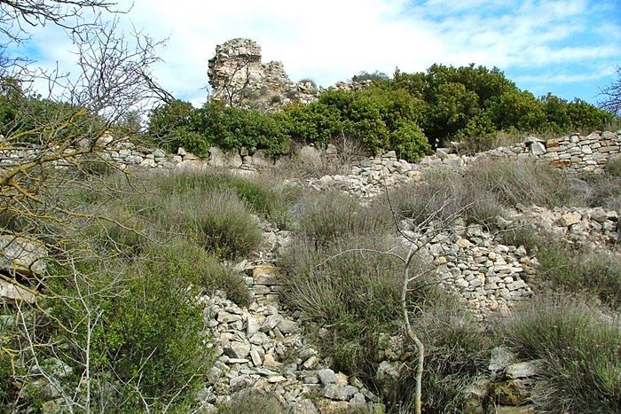
Katarraktis (meaning waterfall) was a medieval settlement and important castle which have been destroyed in the big earthquake of 1881.
After that disaster, the survivors moved to a new location, the modern village Katarraktis on the eastern coast of Chios. The abandoned old village became known as Palios (old) Katarraktis.
History
The old village of Katarraktis was on a low hill 2 km SW of the modern seaside village. Atop this hill the Genoan lord Antonio Rocca-Gustiniani built a castle in 1484.
The Gustiani family were the administrators of the Genoan company Mahona and the rulers of Chios from 1347 until 1566.
Contemporary travelers described this castle as powerful and well-built. As mentioned, it was destroyed in 1881 by an earthquake. Despite this, some remains of the buildings and of the fortification are still visible.
The site has become a minor tourist attraction, but has not attracted the attention it deserves from scholars (maybe because it was wrongly believed, until recently, that it was a construction of the 16th century, after the Ottoman conquest).
| First entry in Kastrologos: | March 2016 |
Sources
- Wikipedia article - Καταρράκτης Χίου
- Γεωργίου Ι. Ζολώτα: Ιστορία της Χίου, τόμος Α («Ιστορική Τοπογραφία και Γενεαλογία»). Τύποις Π.Δ. Σακελλαρίου, Αθήναι 1921, σσ. 612-615
- Website Καταρράκτης Χίου
|
|
| Access |
|---|
| Entrance: |
| Free access |


