

Petroto, Oreokastro, Thessaloniki,Central Macedonia
Fortress of Aetos


| Location: |
| On a hill 1 km esat of the village Petroto in Thessaloniki region |
| Region > Prefecture: |  |
| Central Macedonia Thessaloniki | |
| Municipality > Town: | |
| City of Oreokastro • Petroto | |
| Altitude: | |
|
Elevation ≈ 242 m (Relative Height≈90 m) |
| Time of Construction | Origin | |
| Middle Byzantine period | BYZANTINE |
|
| Castle Type | Condition | |
| Castle |
Rather Poor
|
Ruins of a castle of the Midle-Byzantine period on a low hill maned Kales or Goules (meaning castle in Turkish) east of the village Petroto near Thessaloniki, on the east bank of Gallikos river.
History
This castle is identified with the fortress of Aetos known from historical sources. (Moutsopoulos, 2004)
Actually, the castle is mentioned by a single Byzantine source, by the 12th-century historian Nikephoros Bryennius the Younger, who in his work Yli Istorias (Material of History) mentions, in passing, the existence of the castle, in the context of recounting the mutiny of Nikephoros Vassilakis and his defeat by the young general (and later emperor and father-in-law of Bryennius) Alexios Komnenos.
Nikephoros Vassilakis or Vassilakios was Duke of Dyrrachium and an experienced and well-respected general. He was a veteran of the battle of Manzikert (as Duke of Theodosiopolis at the time, in 1071), where he had been captured and, later, freed together with the emperor Romanos Diogenes.
In 1077, towards the end of the disastrous reign of Emperor Michael IV Doukas, various military movements against the emperor had taken place. Among those who revolted was Vasilakis in Dyrrachium, who, however, decided to take action late, in the spring of 1078, when the general Nikephoros III Botaneiatis had already ascended the throne, having defeated another rebel, Nikephoros Bryennius.
So in the spring of 1078, Vasilakis moved east with an army of Franks, Slavs, Albanians and Greeks and captured Thessaloniki, where he was welcomed as a savior by the local population, as the central administration was in Constantinople in a spin.
Vassilakis stayed for several months in Thessaloniki where, apparently, he had proclaimed himself emperor. He even minted his own coin.
The threat was serious for Nikephoros III Botaneiatis, as Vasilakis had under his control a large territory, while he was also politically strong having the support of many powerful families of Byzantium. In the summer of 1078, Botaneiatis decided to send against Vasilakis an army led by the young but very capable general Alexios Komnenos. Vasilakis for some reason decided to exit Thessaloniki with his army and moved north.
According to the historian Nikephoros Bryennios (book D,19), Vassilakis, leaving the city of Thessaloniki, moved outside the main road without being noticed by his enemy and from a small road that passed through Liti, he arrived at the river Gallikos which he passed at a point near the fortress of Aetos and from there entered the plain between the Axios and Gallikos rivers.
Vassilakis, after crossing the Gallicos river, camped on the banks of the Axios, 18 miles from Thessaloniki. There he was surrounded at night, after a ruse, by Alexios and defeated. He fled to Thessaloniki, where the citizens handed him over to the imperial army after a while. Thus, in early 1079, the rebellion ended. Vasilakis was blinded somewhere near Kavala while being transported to Constantinople.
It was one of the most characteristic incidents of the short reign of Nikephoros Botaneiatis but also of the early career of the great Alexios Komnenos. And it was the only time in history that the fortress of Aetos was mentioned by someone.
Beyond the almost certain identification of the castle of the present page with the Byzantine fortress of Aetos, we have no other information that could help date the castle. It was apparently built during the mid-Byzantine period, before the end of the 11th century, but exactly when is unknown.
A possible period of construction is the reign of Romanos I Lekapinos, in the first decades of the 10th century when several castles were built in Macedonia to strengthen the defense against the Bulgarians who, under Tsar Simeon, had begun to creat serious problems again. Another possible period is the early 9th century, during the reign of Michael II Traulos (or Psellos- the Stammerer), between 820 and 828, when various castles are known to have been built in Macedonia (we do not know which ones exactly), again because of the Bulgarians.
However, these are all assumptions. We do not know exactly when during the Middle Byzantine period the castle was built, while no thorough research has been done on the site.
Structure, Fortification & Buildings
The layout of the castle is almost rectangular with the long dimension on the NW-SE axis.
The perimeter of the walls is 300 meters and the surface area within the walls just over 5000 sq.m.
The fact that the fortification encloses a relatively large area, by the standards of the time, shows that there was a Byzantine settlement on the hill and not just a military fortress. This assumption is supported by the fact that neither the fortification was particularly strong nor the hill particularly inaccessible.
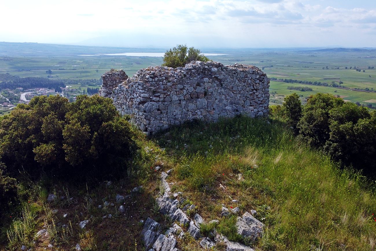
At the highest point dominates a massive rectangular tower, which survives at a considerable height, about 3 meters, and is visible from a distance. Its dimensions are approximately 8✖8.5 meters with a wall thickness of 2 meters. It is built with stones with ceramics in the voids connected together with plaster.
Inside the ground floor of the tower, on its south side, a long narrow cistern with dimensions of 2.5✖0.8 meters can be seen.
The walls of the fortification are in a much worse condition than the tower. Much of it has been covered by vegetation while many parts have been precipitated on the slopes of the hill. However, the outline of the fortification is clear (by satellite too).
The best preserved part of the walls is on its south-southeast side with a thickness of 1.5 meters and a height that does not exceed 1 meter.
This side of the fort is separated by a small ridge from the adjacent level hill and was the most vulnerable defensively. The remaining sides of the fort have a steep downhill slope and provide natural protection.
No building is preserved inside the castle. Some stone piles can be seen inside and outside the fortress, which are obviously the remains of buildings.
It is worth mentioning the existence of a small pit, a few meters north of the tower, near the northern wall. On a simple visual inspection from above, it appears to be about 3 meters deep, then narrows and it is unknown how far it continues (generally, such holes raise suspicions of secret tunnels leading out of the castles, which is not at all a myth).
| First entry in Kastrologos: | July 2022 |
Sources
- ΜΟΥΤΣΟΠΟΥΛΟΣ Κ. ΝΙΚΟΛΑΟΣ «Άγνωστα βυζαντινά κάστρα της Μακεδονίας», Εκδόσεις Νησίδες, 2004, p.107-124
- Research, photos, video and info by Sakis Amfiteides and his blog ΑΜΦΙΤΡΕΙΔΗΣ (2022)
|
|
| Access |
|---|
| Approach to the monument: |
| SE from Petroto, an uphill dirt road begins that after 1 km leads to a small church of Prof. Elias. We continue on foot to the north, seeing the ruins of the castle. We arrive in 30 minutes trekking on a rough, unmarked path, through dense vegetation. |
| Entrance: |
| Free acces |
| Other castles around |
|---|
| Eptapyrgio |
| Gynaikokastro |
| Lefkos Pyrgos |
| Castle of Nea Santa |
| Castles of Thessaloniki |
| Fortress of Vardari |


