

Lachanas, Langadas, Thessaloniki,Central Macedonia
Paliokastro of Lachanas
or Paliokastro of Asar


| Location: |
| On a low wooded hill 1.5km west of the village Lachanas north of Thessaloniki |
| Region > Prefecture: |  |
| Central Macedonia Thessaloniki | |
| Municipality > Town: | |
| City of Langadas • Lachanas | |
| Altitude: | |
|
Elevation ≈ 650 m (Relative Height≈50 m) |
| Time of Construction | Origin | |
| 10th cent. | BYZANTINE |
|
| Castle Type | Condition | |
| Castle Ruins |
Few Remains
|
Few remnants of a Byzantine fortification on a wooded low hill 1.5 km west of Lachanas and 3.5 km north of Xylopolis, in the northern part of the prefecture of Thessaloniki.
The name of the hill is Paliokastro (meaning “old castle”). Its old name was Asar which derives obviously from the Turkish hisar meaning also castle.
History
There are traces of life on the hill since the Iron Age, while there have been ceramic findings from the Archaic Period. The fortification is Byzantine and was built in two phases. The older phase belongs to the 7th or 8th century and a more recent phase is from the 10th century, probably.
Apparently, there was a Byzantine town around this hill and Paliokastro was its citadel and administrative center. We do not know the name of the town and there are no remains of it, as the fields around the hill are cultivated.
According to the oral tradition of nearby Xylopolis, Asar was inhabited until the beginning of the Ottoman period. In the 16th century, it was abandoned and its population moved to Xylopolis. However, there is no evidence of habitation on the hill after the 10th century.
Structure, Fortification & Buildings
The fortification is destroyed and only small parts remain. Moreover, the dense vegetation hides what is left.
The castle is elliptical in shape. It covers an area of about 14,000 sq.m. within an initial perimeter of 450 meters, of which about 80 meters of wall fragments are visible today.
The major axis of the ellipsoid is in the East-West direction. The fortification has two construction phases: Parts of the older phase, probably dating back to the 7th or 8th century, are preserved in three places: on the east and north sides, in lengths from 8 to 12 m, and at a low height, 60 to 120 cm.
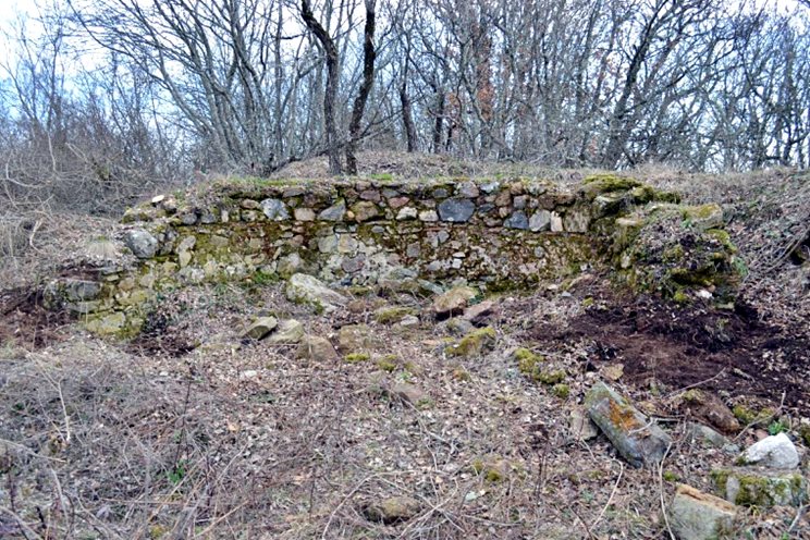
The newer phase, probably built around the 10th century, is located on all sides, with the best surviving part being located in the southwest, where it is maintained at a length of about 35 m, with a surviving height of about 3m and a thickness slightly larger than 1m. The two phases overlap on the north side, where the newer one is built behind the older one.
There are strong indications for the presence of a rectangular tower on the south side, above the access road, where the only entrance would probably be. The masonry of the newer phase seems more diligent. On the south side, there is a brick cross, the only surviving ceramic decorative element of the fortification.
Apart from the ruins of the wall, the only other structure found today is on the plateau at the top of the acropolis, where there was a church dedicated to the Virgin, according to the local tradition of the neighboring Xylopolis (photo 1). Today, only the lower part of its large semicircular niche is visible, which was discovered after illegal excavations, due to which the remaining walls of the church were demolished. The masonry of the arch dates it around the 8th century.
| First entry in Kastrologos: | July 2020 |
Sources
- E. Παπαθανασίου – Ν. Παζαράς, Επιφανειακή έρευνα στο «Παλαιόκαστρο» Λαχανά, Παρουσίαση στην επιστημονική συνάντηση ΤΟ ΑΡΧΑΙΟΛΟΓΙΚΟ ΕΡΓΟ ΣΤΗ ΜΑΚΕΔΟΝΙΑ ΚΑΙ ΤΗ ΘΡΑΚΗ , Μάρτιος 2018
|
|
| Access |
|---|
| Entrance: |
| Free access |
| Other castles around |
|---|
| Castle of Nikokleia |
| Castle of Kalokastro |
| Castle of Strymonikon |


