

Strymoniko, Herakleia, Serres,Central Macedonia
Castle of Strymonikon
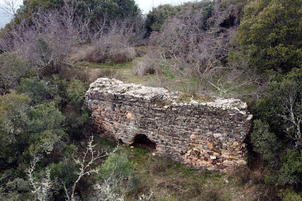
1
2 / 10

part of the north wall
3 / 10

part of the north wall
4 / 10

part of the west wall
5 / 10

part of the west wall
6 / 10

the wooded hill of the castle
7 / 10

view to Strymoniko from the NE corner of the castle
8 / 10

the hill and the surrounding area from SW
9 / 10

southeast side
10 / 10


THE END
| Location: |
| Atop a wooded hill 2.5km SW of the village Strymoniko in Serres prefecture. |
| Region > Prefecture: |  |
| Central Macedonia Serres | |
| Municipality > Town: | |
| City of Herakleia • Strymoniko | |
| Altitude: | |
|
Elevation ≈ 265 m (Relative Height≈130 m) |
| Time of Construction | Origin | |
| perhaps 3 - 4th cent. | Early ΒΥΖΑΝΤΙΝΕ |
|
| Castle Type | Condition | |
| Castle Ruins |
In Ruins
|
Few ruins of an unknown castle on a hill called “Kales”, 2.5 km west-southwest from the village of Strymoniko in the area of the Strymonas valley in the prefecture of Serres.
History
We know nothing about the history of the castle, which has not been identified with any castle known from historical sources.
The only thing we have from the medieval sources is a reference to the village of Strymoniko, which in the Byzantine Period was called “Ourliakon”, in the year 1321 in a record of the census of the thema of Thessaloniki. (The name Urliakon is of Slavic origin and means eagle's place. It survived as Orliako until 1927, when the name was changed to Strymoniko.) However, Orliako/Strymoniko is quite far away and this reference should not be related to the castle if we also consider that the castle has no signs of habitation at that time.
By the archaeological service, Kales has been declared an archaeological site “in which there are remains of a castle with surface findings that are mainly from Roman times and remains of Byzantine fortifications”. (Law 472/AAP/8-11-2010)
Based on this element and the type of construction, we will assume that the castle was created during late antiquity, perhaps in the 3rd century AD. when with the end of the Pax Romana and the invasion of various barbarian tribes in the Balkans, the rural populations began to seek refuge in fortified settlements. It was probably abandoned as invasions intensified in the following centuries. This must have happened at the latest with the descent of Slavs and Avars at the end of the 7th century.
Structure, Fortification & Buildings
The castle is built on the top of a hill, which is part of the Krousia range. It is located next to the modern Serres-Thessaloniki road,
The hill is covered with dense vegetation. A stream flows at the northern foot of the hill.
Few ruins of the fortification survive from the castle. The wall had a perimeter of about 450 meters and its structure consisted of stones of different sizes with binding mortar between them and fragments of pottery in the gaps.
The best-preserved part of the wall is in the southeast corner (photos 1, 9). This section is approximately 8 meters long, 2.5 meters high and 1.50 meters thick. It is at the point where the most vulnerable point of the castle was located, and this is because on its southern side a neck is formed that joins the hill of the castle with the adjacent higher slope.
On the northern side, parts of the wall up to 2 meters high are preserved (photos 2, 3).
Some parts of the western wall are preserved at a low height of 1 to 1.5 meters. (photos 4,5)
The rest of the fortification is preserved at a low height or has been covered by vegetation, but the traces of the course it followed are evident. In earlier investigations (Samsaris, 2004) remains of buildings inside the castle were reported, which are not visible today beyond some scattered stones and few ceramics. Only at the top of the castle, at the highest point, were the foundations of a rectangular building observed.
Nowhere in the castle were traces of a tower found. (Perhaps the vegetation hides them.)
| First entry in Kastrologos: | February 2023 |
Sources
- Info and photos by Sakis Amfitreidis and his blog ΑΜΦΙΤΡΕΙΔΗΣ (January 2023)
- Σαμσάρης, Πέτρος «Βυζαντινοί τόποι και μνημεία της κάτω κοιλάδας του Στρυμόνα», 2004, Πανεπιστήμιο Ιωαννίνων – Διδακτορική Διατριβή, 2004, σελ. 716, 123-124
|
|
| Access |
|---|
| Approach to the monument: |
| From the western edge of Strymoniko village starts a dirt road running parallel to the stream. After 2 km we turn left. After an uphill 2.5 km route we arrive below the castle. We continue on foot. At 50m is the south side of the castle. |
| Entrance: |
| Free access. Unclear paths and vegetation makes it very difficult. |
| Other castles around |
|---|
| Tower of Andronikos |
| Castle of Nikokleia |
| Castle of Kalokastro |
| Paliokastro of Lachanas |
| Castle of Nigrita |
| Sidirokastro Castle |


