

Nigrita, Visaltia, Serres,Central Macedonia
Castle of Nigrita


| Location: |
| On a low hill in the fields 2.5km south of Nigrita in Serres perfecture, Central Macedonia |
| Region > Prefecture: |  |
| Central Macedonia Serres | |
| Municipality > Town: | |
| City of Visaltia • Nigrita | |
| Altitude: | |
|
Elevation ≈ 210 m (Relative Height≈50 m) |
| Time of Construction | Origin | |
| Before 6th cent. | Early ΒΥΖΑΝΤΙΝΕ |
|
| Castle Type | Condition | |
| Castle Ruins |
In Ruins
|
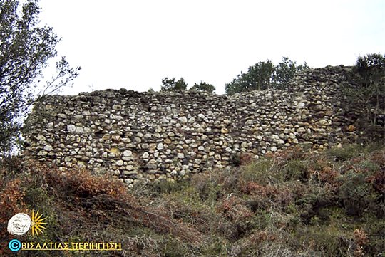
Remains of a fortification on a low hill south of the town of Nigrita.
History
The fortification is not mentioned by the sources. The construction indicates an Early-Christian origin, i.e. it was built before the 4th century AD.
It was rather strong and big for the standards of that period, so perhaps it protected a relatively important settlement. It is possible that its purpose was to guard the mines of the region which operated at least until the early-byzantine years.
The lack of historical reports about the castle and the absence of signs of more recent repairs indicate that the fortification was not in use in the middle byzantine period and later.
Structure, Fortification & Buildings
The initial dimensions of the castle were 35✖42 meters. Only the western side is preserved today to a height of 4.20 m.
The thickness of the wall does not exceed 1.50m.
| First entry in Kastrologos: | December 2017 |
Sources
- Petros Samsaris, (2004)“ Byzantine places and monuments of the lower valley of the Strymon river. ”, page 692
- Pictures from Panoramio, user ΒΙΣΑΛΤΙΑΣ ΠΕΡΙΗΓΗΣΗ
|
|
| Access |
|---|
| Entrance: |
| Free access |


