

Stefanina, Volvi, Thessaloniki,Central Macedonia
Castle of Stefanina


| Location: |
| On a wooded slope of mount Kerdyllia, 2.5km NE of the village Stefanina in Central Macedonia |
| Region > Prefecture: |  |
| Central Macedonia Thessaloniki | |
| Municipality > Town: | |
| City of Volvi • Stefanina | |
| Altitude: | |
|
Elevation ≈ 770 m (Relative Height≈230 m) |
| Time of Construction | Origin | |
| probably 8th cent. | BYZANTINE |
|
| Castle Type | Condition | |
| Castle |
Rather Poor
|
Castle ruins of the Middle Byzantine Period on a wooded hill in the Kerdyllia mountains, northeast of the village of Stefanina in the municipality of Volvi with a wide field of view towards the Vromolimni plateau.
History
The first reference in historical sources about Stefanina is found in a document of the 11th century, specifically in the year 1083, when the Domesticus of the West Grigorios Pakourianos dedicated the village of Prilongion to the monastery he founded in Batskovo Bulgaria. According to the document, the village was in the Archonteia called “Stefaniana”.
The term “Archonteia” (Αρχοντεία) meant a military and administrative center of a region, something like a barony. This barony may have existed from the first half of the 9th century, if not from the end of the 8th century. Stefaniana evolved in the second half of the 13th century into the Katepanikion of Stefaniana.
The castle itself is first mentioned in 1346, when its commander was the Serb general Grigori Preliub.
The identification of the castle would have been easy since the name of the village remains the same. However, there is a problem here because inside the village are the remains of another medieval fortification called the “tower of Stefanina”.
Most probably, the castle of the current page was the initial castle of Stefanina built around the 8th century. The “tower” inside the village was constructed later in the Late-Byzantine Period, when the settlement moved to its current location. According to this –unverified– hypothesis, the castle of 1346, it must have been the tower inside the village.
Structure, Fortification & Buildings
The fortification extends over an area of approximately 6500 sq.m. Its layout has a polygonal shape. To the east of the hill there is the Neromana stream.
The slopes of the hill are quite steep, providing natural protection. Its most vulnerable side is the north, in which a moat is formed between the descending slope and the castle.
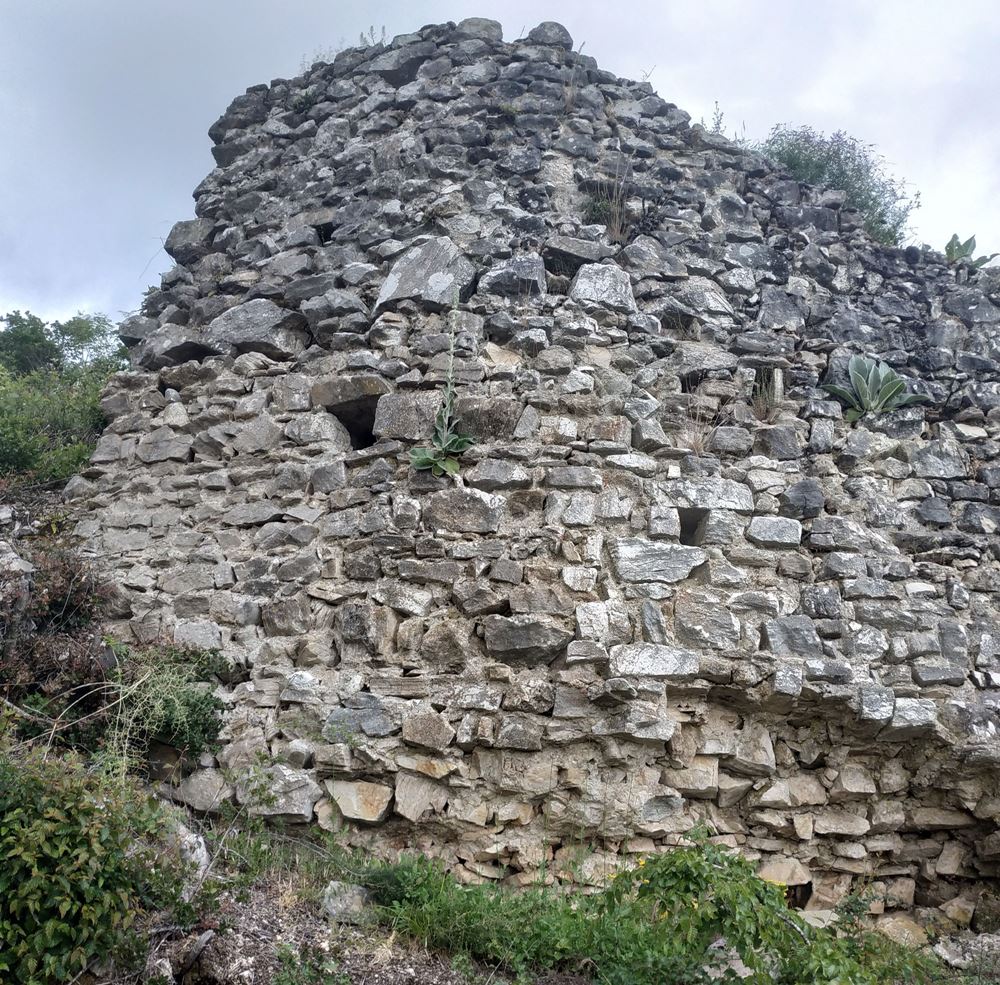
The hill is surrounded by a wall that follows the rugged terrain with a total length of 300-350 meters which is in a dilapidated state.
In the area there is dense vegetation that has covered most of the castle.
The wall is better preserved on the western side, while on the eastern side, it is preserved at a small height.
The best-preserved part, and also the most characteristic of the castle, is located in the northwest corner at a height that reaches 4.5 meters and a thickness of 1.80m.
At about the middle of the west wall is a wall about 3 meters high with a surviving rainwater drain hole. Unfortunately, it seems that the spot was a place of illegal excavation (photo 4).
A part of the wall with a height of 2 meters and a thickness of 1.80 meters is preserved in the southwest corner. Here is also the lowest altitude point of the castle (750 meters).
| First entry in Kastrologos: | November 2022 |
Sources
- Research, text and photos by Sakis Amfitreidis and his blog ΑΜΦΙΤΡΕΙΔΗΣ (Oct 2022)
- Ευάγγελος Παπαθανασίου, Τεκμήρια Ιστορίας στον Δήμο Βόλβης-2019 (Αφιέρωμα στα 40 χρόνια προσφοράς του Νικόλαου Μουτσόπουλου στην γη της Μυγδονίας), κεφάλαιο: Μικρή Συμβολή στην ιστορική τοπογραφία της περιοχής του Καπετανικίου των Στεφανιανών, σελ. 122-144
- Ευάγγελος Παπαθανασίου- Μαρίζα Τσιάπαλη, ΑΠΟ ΤΑ ΜΑΚΕΔΟΝΙΚΑ ΣΤΑ ΘΕΣΣΑΛΙΚΑ ΤΕΜΠΗ - 2019, κεφάλαιο: Η Κλεισώρεια Ρεντίνης-Στεφανηνών: Ορισμός-Χαρακτηριστικά- Αμυντική οργάνωση μέσα στο χρόνο σελ. 31-41
|
|
| Access |
|---|
| Approach to the monument: |
| To the SE of the village begins a dirt road that passes through the Neromanas stream. 150m after the stream, turn right towards the mountain. After 4km we meet a downhill dirt/road on the right. We continue on foot. After 250m we see the castle opposite. |
| Entrance: |
| Free access but the visit is very difficult because of the dense vegitation. |


