

Redina, Volvi, Thessaloniki,Central Macedonia
Castle of Rentina
or Artemision castle


| Location: |
| Redina, 71st Old Nat.Road Thessaloniki-Kavala |
| Region > Prefecture: |  |
| Central Macedonia Thessaloniki | |
| Municipality > Town: | |
| City of Volvi • Redina | |
| Altitude: | |
|
Elevation ≈ 130 m (Relative Height≈40 m) |
| Time of Construction | Origin | |
| 6th century | BYZANTINE |
|
| Castle Type | Condition | |
| Castle |
Not Good
|
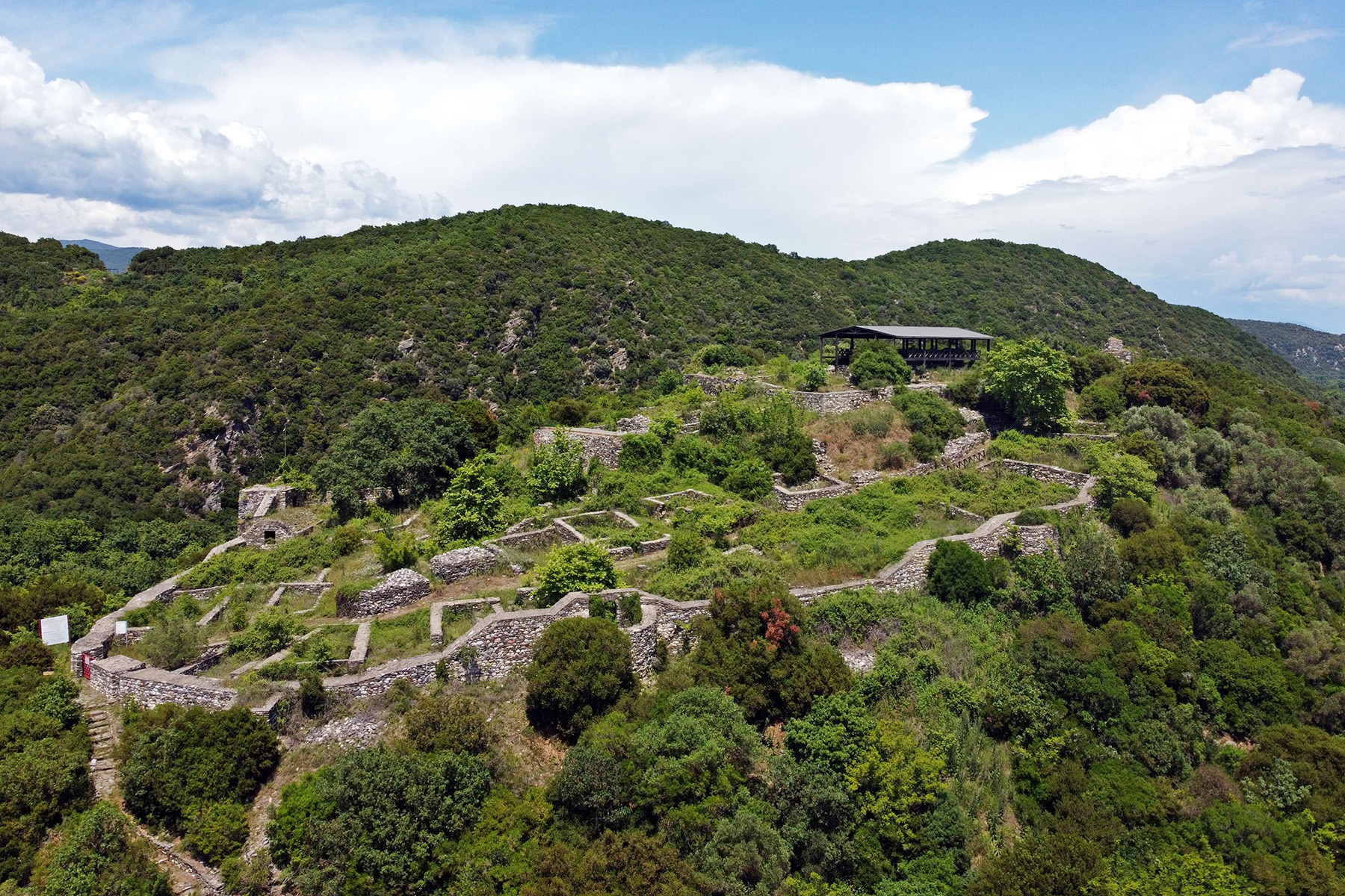
An important castle of north Greece on top of a hill in a very beautiful landscape. Although it is a big castle and very close to a road with heavy traffic, it is not easily visible. Moreover, it is not open to the public.
History
Excavations carried out on the hill and its environs have revealed traces of human presence since Neolithic times; on the basis of their construction and associated finds, the building walls and abutments unearthed in the southwest section of the castle date to the Hellenistic period. Rentina lies close to the settlement of Arethousa, which went into decline from the 6th century onwards. According to one interpretation, Rentina may take its name from the nearby staging post (mutatio) called Peridipidis (genitive: Peripidinis).
The fortifications at Rentina are reasonably well preserved, as are the impressive remains of a settlement that may well be Artemision Castle, referred to by Procopius in his work On Buildings as having acquired fortifications in the time of Justinian. Nevertheless, research findings to date indicate that the first fortifications, which included water cisterns capable of supporting a small guard, should be dated to the mid-4th century. Under Justinian the wall was reinforced with towers and equipped with a large cistern on the level ground in the citadel.
In mid-Byzantine times the wall was rebuilt to serve as fortifications for a settlement founded in the first half-decade of the 10th century, when it was seat of the Diocese of Lete and Rentina. At that time a church was built over the ruins of the then defunct cistern on the citadel, together with accommodation for the bishop and his retinue. By the end of the same century several houses had been erected in the lower town, following the line of the old wall and on stepped terraces. A third wall then surrounded the settlement from the most vulnerable section to the west, where a tower was built. Wood remains from the interior of this have been carbon dated to around 980 AD.
After 1204 the settlement was surrendered to the rulers of the Frankish Kingdom of Thessalonica. As indicated by the large number of contemporary coins found in excavations, they appear to have installed a permanent guard, with the obvious aim of controlling the Plain of Thessalonica and the Strymonic Gulf.
In 1242 John Vatatzes took the castle while marching on Thessalonica, since, as George Acropolites would have it, the Franks abandoned their position without a fight. News of the inhabitants of Rentina in the 13th and 14th century is contained in legal documents held by monasteries on Mount Athos, where mention is made of lands, mills and houses in the area. In the first half-decade of the 14th century a small cruciform church was built inside the eastern enclosure, possibly in connection with an infant and child cemetery.
In the mid-14th century it appears that the inhabitants gradually abandoned the settlement, which passed successively into the hands of Serbs, Greeks and then Turks. The arrival of Turkish Yuruks in the area probably led the greater part of the population to seek the safety of larger centres, the most prominent of which was Volvi. The few coins excavated from that time up until the mid-16th century are illustrative of the decline of the once flourishing settlement at Rentina, confirming the existence of a small-scale farm on the same site.
Structure, Fortification & Buildings
The first fortifications around the settlement have been dated to the mid 4th century. They included a five-sided citadel and a wall surrounding the south-west part of the hill. Access was gained via two gates: a main gate with a narrow postern in the west part of the wall, and a secondary one in the south section.
These initial defences were reinforced at least 4 more times in subsequent periods.
In the reign of Justinian the fortifications were built higher, and a semi-circular tower was added to the south branch of the wall. It was then that a large water tower was erected in the open, flat part of the citadel. The settlement was founded when the seat of the bishopric of Lete was transferred to Rentina in the 10th century, at which time rectangular towers were added to the corners of the walls around the citadel and the lower city, and at other vulnerable points that needed bolstering. At the same time a triangular wall was built around part of the hill from the eastern side, running along the rocks on the brow. There do not appear to have been any buildings inside the east wall, which was probably used to protect the residents’ flocks in times of siege. The inside of the keep was full of wooden frames between layers of earth, which have been dated to c. 980 A.D. by the carbon 14 (C14) dating method. A roofed semi-underground corridor started at the base of tower and led to an underground water tower with a double antechamber, which had a corbelled dome ceiling. The tower gathered water from a nearby stream, and was used either to store drinking water or as an underground workshop for the production or storage of useful or precious products.
As it was built on a steep incline, the tower did not last long; it was abandoned in the 12th century along with two sections of the eastern wall. From then on the east side of the hill was protected by two powerful walls running down to the bottom of the hill behind the citadel. These were strengthened with stone facing in a subsequent period. It was probably then that the south wall gate was blocked up for greater safety.
After 1204 the Franks strengthened the citadel wall by repairing the northern rectangular tower and the north exterior surrounding wall, which had been founded at a relatively unassailable point. After the castle was taken by John Vatatzes and his army (1242), a new keep was built to the east of the citadel, at the intersection of the two strong double walls running down to the side branches of the initial east wall. This was designed to protect both the guard and the inhabitants. The walls and the entire settlement were abandoned after the mid-14th century.
| First entry in Kastrologos: | March 2012 | Last addition of photo/video: | May 2023 |
Sources
- blog: Protostator, blogpost: "Το κάστρο της Ρεντίνας"
- Website Exploring the Byzantine World -Rentina-The walls
- 3D model by Kostas Chaidemenos
|
|
| Access |
|---|
| Approach to the monument: |
| The castle is practically on the Old National Road Thessaloniki-Asprovalta. A couple of kilometers before the junction to Stavros, Chalkidiki. |
| Entrance: |
| Entrance to the castle is not allowed. |


