

Dafni, Visaltia, Serres,Central Macedonia
Castle Of Ezevai
1
2 / 18

the hill of the castle from the north
3 / 18

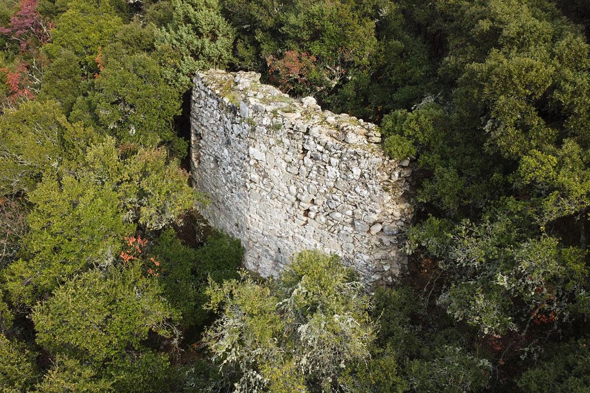
wall of the western corner
4 / 18

wall of the western corner
5 / 18

part of the south wall
6 / 18

part of the south wall
7 / 18

southeastern corner of the wall
8 / 18

part of the eastern wall
9 / 18

part of the eastern wall
10 / 18

part of the north wall with two openings
11 / 18

part of the estern wall
12 / 18

part of the estern wall
13 / 18

a cistern/well next to the eastern wall
14 / 18

a cistern/well in the middle of the castle
15 / 18

ruins of a rectangular building inside the castle
16 / 18

ruins of a building inside the castle
17 / 18

vathra of Kotsvini
18 / 18


THE END
| Location: |
| In a semi-mountainous area 2.5 km SW of the village Dafni in Serres prefecture of Macedonia |
| Region > Prefecture: |  |
| Central Macedonia Serres | |
| Municipality > Town: | |
| City of Visaltia • Dafni | |
| Altitude: | |
|
Elevation ≈ 220 m (Relative Height≈50 m) |
| Time of Construction | Origin | |
| 11th century | BYZANTINE |
|
| Castle Type | Condition | |
| Castle |
In Ruins
|
Ruins of a Byzantine castle on a wooded hill 2.5 km southwest of the town of Dafni and 1.5 km southwest of the settlement of Oreskeia in the prefecture of Serres.
The area is relatively isolated, at the foot of the Kerdyllion mountain.
The castle is identified (in all probability) with the castle of Ezeva or of the Ezevai mentioned in the sources from the 11th century onwards.
A large part of the hill is surrounded by a stream, the Ezovitis, which in some places forms deep ponds locally called “vathres” and which seem to be an attraction of the area, as from Oreskeia there are signs showing the road (i.e. dirt road) to the vathres (no mention of the castle).
History
The relatively large area enclosed by the fortification and the numerous historical references that exist show that Ezevai was not just a fortress, but a settlement and even an important one since it was the seat of a bishopric.
Ezeva or the Ezevai was a diocese, a castle and an enoria (territory) having given its name to the wider area that included several villages.
There are many references to Ezevai and its villages during the Byzantine period (11th century onwards) and during the Turkokratia. But especially for its castle there are four mentions that start from the middle of the 11th century to the beginning of the 12th.
In 1290, the bishop of Ezevai was Ioannikios who was the founder of the monastery of Timios Prodromos in mount Menoikion.
It is not known when the castle was abandoned. This must have happened at the beginning of the Tourkokratia (which for the region started at the end of the 14th century) when the populations moved to the plains. In this case, the inhabitants of the castle moved to present-day Dafni and the surrounding villages. It should be noted that in Dafni there is the tower of Maro from the 15th century, but there are no traces of a castle (which means that the castle of Byzantine Ezebai could not have been in Dafni).
Structure, Fortification & Buildings
The castle is built on the top plateau of a remote hill named Paliomonastirο. The hill has very steep slopes. At the foot of the hill runs the stream of Ezovitis, which functions as a natural moat.
The castle is in a dilapidated state. It is protected by a polygonal external wall with a perimeter of approximately 500 meters. The wall is preserved in fragments, in some places at a sufficient height, up to 5 meters, while in others it has collapsed or been covered by the vegetation of the hill.
The wall is made of local stones and river stones of different sizes, with binding mortar between them and sparse use of ceramics without regular arrangement. Inside the castle there was a settlement.
The best preserved part of the wall and the most characteristic is located in a corner on the western side of the hill (photos 1, 3, 4). It is a section of wall 8 meters long with a height reaching 4.5 to 5 meters and a thickness of 1.80m. It is the only part of the wall that is visible from afar. A hole (30✖35cm), possibly for water drainage, is preserved in the wall in question, approximately in the middle.
On the south side, parts of the wall are preserved at a low height. The best preserved part is located approximately in the middle of this side and reaches a height of 3m.
The east side is the only one not protected by the stream. But it has particularly steep slopes and access to it could only be made through a narrow, rugged and neck formed by the adjacent hill.
And here only parts of the wall is preserved in some places.
On the northern side, the fortification is in the same ruined state, while on the western side, some massive sections of wall up to 3 meters high are preserved. At the foot of the hill on the north side is the impressive Kotsvini vathra (pond).
Within the walls there was a settlement. Building foundations, a dense presence of stone piles and scattered stones, ceramics and pieces of tiles (probably from roofs) can be observed throughout the area.
In some places in the southern part of the castle, the piles of stones are quite massive and elevated, giving the impression of ruins of quite large buildings.
| First entry in Kastrologos: | January 2023 |
Sources
- Research, info and photos by Sakis Amfitreidis and his blog ΑΜΦΙΤΡΕΙΔΗΣ (December 2022)
- Πέτρος Σαμσάρης, «Βυζαντινοί τόποι και μνημεία της κάτω κοιλάδας του Στρυμόνα. Ο σημερινός νομός Σερρών: συμβολή στη μελέτη της ιστορικής γεωγραφίας και μνημειακής τοπογραφίας της περιοχής» (Διδακτορική διατριβή-2004), κεφάλαιο 3ο, στο λήμμα: Επισκοπή Εζεβάς (και Στεφανιανών), σελ.: 98-100 και στο λήμμα: Εζεβά σελ. 272-280.
- Ζήκος Νικόλαος, «Εζεβαί : ένας βυζαντινός οικισμός στο κάτω τμήμα της κοιλάδας του Στρυμόνα», ΜΝΗΜΗ ΜΑΝΟΛΗ ΑΝΔΡΟΝΙΚΟΥ-Εταιρία Μακεδονικών Σπουδών, σελ. 77-104.
- Ζαφειρίου Μιχάλης, «Ζήτηνος, Ζίντζος, Τζίντζ(ι)ος, Σιτοχώρι: - Ιστορικογεωγραφικά της νοτιοανατολικής Βισαλτίας, Σερρών», ΙΣΤΟΡΙΚΟΓΕΩΓΡΑΦΙΚΑ-ΠΕΡΙΟΔΙΚΗ ΕΚΔΟΣΗ ΓΙΑ ΤΗΝ ΙΣΤΟΡΙΑ ΓΕΩΓΡΑΦΙΑ ΚΑΙ ΤΟΠΟΓΡΑΦΙΑ ΤΟΥ ΕΛΛΗΝΙΚΟΥ ΧΩΡΟΥ ΚΑΤΑ ΤΟΥΣ ΜΕΣΟΥΣ ΧΡΟΝΟΥΣ-ΤΟΜΟΣ 7ος (2000), σελ. 9-120.
- Ιωάννης Μπάκας, «Συμβολή στην εκκλησιαστική ιστορία της Βισαλτίας», πρακτικά επιστημονικού συμποσίου «Νιγρίτα - Η Βισαλτία δια μέσου της Ιστορίας», Νιγρίτα 1993
|
|
| Access |
|---|
| Entrance: |
| Free access but difficult. |


