

Myrkinos, Nea Zichni, Serres,Central Macedonia
Kaisaroupolis
1
2 / 7

the remaining wall and the mound in the backrond
3 / 7

the remaining wall and the mound in the backrond
4 / 7

the remaining wall
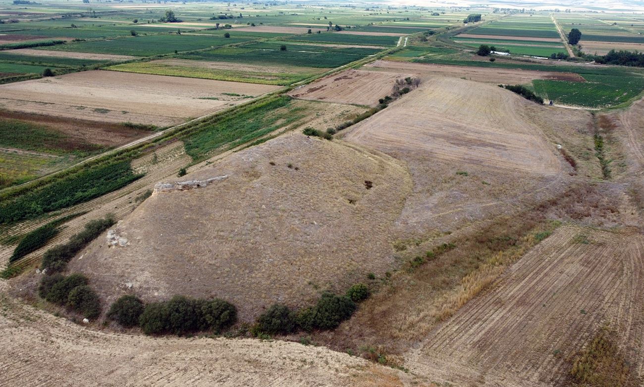
5 / 7

panoramic view of the hill of the castle next to the Aggitis river
6 / 7

the hill from the west
7 / 7

the rocks of the hill in the western and the southern side that look like walls

THE END
| Location: |
| Two kilometers NW of the village Myrkinos in Serres prefecture in Northern Greece |
| Region > Prefecture: |  |
| Central Macedonia Serres | |
| Municipality > Town: | |
| City of Nea Zichni • Myrkinos | |
| Altitude: | |
| Elevation ≈ 20 m |
| Time of Construction | Origin | |
| after 836 | BYZANTINE |
|
| Castle Type | Condition | |
| Castle Ruins |
Few Remains
|
A small fragment from a wall of a castle and a Byzantine city on a characteristic hill named “Gilan Kale” (=snake castle), 2 kilometers north-northwest of the village of Myrkinos and 4 kilometers west of Draviskos in the prefecture of Serres, next to the river Aggitis.
Location & Strategic Scope
The castle today is located in the middle of a plain on a riverside low ground and at an altitude ranging from 10 to 20 meters. The hill is arable land. At a distance of 80-100 meters east of the castle, the Aggitis river passes. After 2.5 kilometers the waters of Agitis flow into the Strymon river
The area consists of an elevated trapezoidal hill that ends on its southern side in a higher steep hill (peak height: 20 meters).
But the morphology of the hill was very different in the past. This is because in the lower part of the Strymonas valley there was the lake of Achinos, which dried up in the early 1930s.
So, the terrain around the fortified city of Kaisaroupolis used to be different. The hill, depending on the season, was surrounded by the waters of the lake or by marshy ground that made it inaccessible.
Indeed, on an Austrian map of the 19th century, the hill in question is depicted with the name "Yilan Kalesi" and the ground around it was a marsh, while the waters of the Aggitis passed on the other side to the west of it. Likewise, on a 1927 map the lake is referred to as Lake Tahinus (of Achinus - Tahinus).

The area on the 1927 map where the dried lake is shown.
History
The ruins have been identified with the Middle Byzantine city of Kaisaroupolis which was the seat of an Episcopate.
This identification is based on the topographical information of the sources but also on the archaeological findings
The identification was first proposed by Stilpon Kyriakidis and is mainly based on a document of 1318 by Michael Neokaisaritis in which the boundaries of the village of Sdravikios (note Draviskos) are defined and the proximity of Keisaroupolis to Doxobous (note Myrkinos) and Sdraviki (Draviskos) is established. The Aggitis River is referred to in the document as ’Panakas“".
Another item is a 11th/12th c. lead seal found at the site with the inscription about a certain Agapios, bishop of Kaisaroupolis.
The city have been founded by Alexios Musele who was a Byzantine general of Armenian origin (of the illustrious Musele or Mosile family) and who for a time had been chosen by the emperor Theophilus (829-842), whose son-in-law he was, as his successor. In the summer of the year 836, Alexios who had recently received the title of Caesar from Theophilus, set out with an army in Thrace to confront the Bulgars. Musele's real aim seems not to have been to fight the Bulgarians (with whom there were then no differences – apart from the repatriation of the Andrianoupolitans) but to use this war as a pretext to seize the coast between Nestos and Strymonas, which they held Slavs according to a treaty of 816. (The Slavs had at that time created numerous semi-autonomous Sclavenia in Macedonia).
The new Caesar without much difficulty conquered the coastal strip, ensuring land communication between Thessaloniki and Thrace and founded a city that gave it the name of the title he held, that is Kaisaroupolis, i.e. Caesar’s town. (Treadgold, p 292).
In the following centuries there are several mentions of Kaisaroupolis in historical sources. Among others, it is mentioned in the Alexias as the place of exile of the army officers who had conspired against the emperor Alexios I Komnenos.
In an Ottoman tax register of 1454/55 the place is recorded as “Kesseroboli” with approximately 79 inhabitants. No other reference to Kairaropolis has been found in later documents.
So Kaisaroupolis was abandoned at an unknown time during the Turkish occupation.
Structure, Fortification & Buildings
The castle was surrounded in the past by a wall. Its perimeter is evident by observing the relief of the ground and is estimated at approximately 700 meters.
All that survives today is a small section of wall in the middle of the eastern side, 6 meters long, 1.70 meters thick and 2 meters high. (photos 2, 3, 4)
The construction of the wall consists of stone construction with binding mortar between and ceramics.
The reason that only this part of the wall is preserved is the fact that the wall and the buildings inside it were destroyed by the construction company that was carrying out drainage works of the lake, in the 1930s, in search of stones, which are rare in the surrounding area. In fact, several marble fragments that came from a Byzantine church in the castle, were transferred to the church of nearby Draviskos.
In the southern part of the hill rises a steep mound 10-15 meters higher than the rest of the hill (photo 7). The mound forms a long narrow plateau at its top (60✖8m.). The vertical rocks present of the western and southern ridge give the impression of fortification. From the imposing cliff, the visibility in the surrounding area from the point is 360 degrees. At the top of the hill, but also in general throughout the area, there are plenty of scattered ceramics.
| First entry in Kastrologos: | October 2023 |
Sources
- Research, presentation and photos by Sakis Amfitreidis and his blog ΑΜΦΙΤΡΕΙΔΗΣ (September 2023)
- WARREN TREADGOLD, "The Byzantine Revival 780-842",1988, page 291-292.
Σχετικός σύνδεσμος: https://www.scribd.com/document/474459964/epdf-pub-the-byzantine-revival-780-842-pdf - Σαμσάρης, Πέτρος «Βυζαντινοί τόποι και μνημεία της κάτω κοιλάδας του Στρυμόνα», 2004, Πανεπιστήμιο Ιωαννίνων – Διδακτορική Διατριβή, 2004, σελ. 316-320
- Μερτζίδης, Σταύρος, Οι Φίλιπποι : Έρευναι και μελέται χωρογραφικαί υπό αρχαιολογικήν, γεωγραφικήν, ιστορικήν, θρησκευτικήν και εθνολογικήν έποψιν , 1897
|
|
| Access |
|---|
| Approach to the monument: |
| Through an asphalt road that starts NW of Draviskos heading west, ending after 3km at an old railway bridge, from where we continue on foot. |
| Entrance: |
| Free access |


