

Dafnoudi, Emmanouil Pappas, Serres,Central Macedonia
Castle of Dafnoudi
1
2 / 16

the hill of the castle
3 / 16

western wall
4 / 16

western wall
5 / 16

western wall
6 / 16

loophole
7 / 16

fragment of northern wall
8 / 16

fragment of northern wall
9 / 16

fragment of northern wall
10 / 16

fragments of the south fortification
11 / 16

traces of stone-paved road on the northern hill neck
12 / 16

cave at the eastern steep side of the hill
13 / 16

cave at the eastern steep side of the hill
14 / 16

a grave in the nearby hill
15 / 16

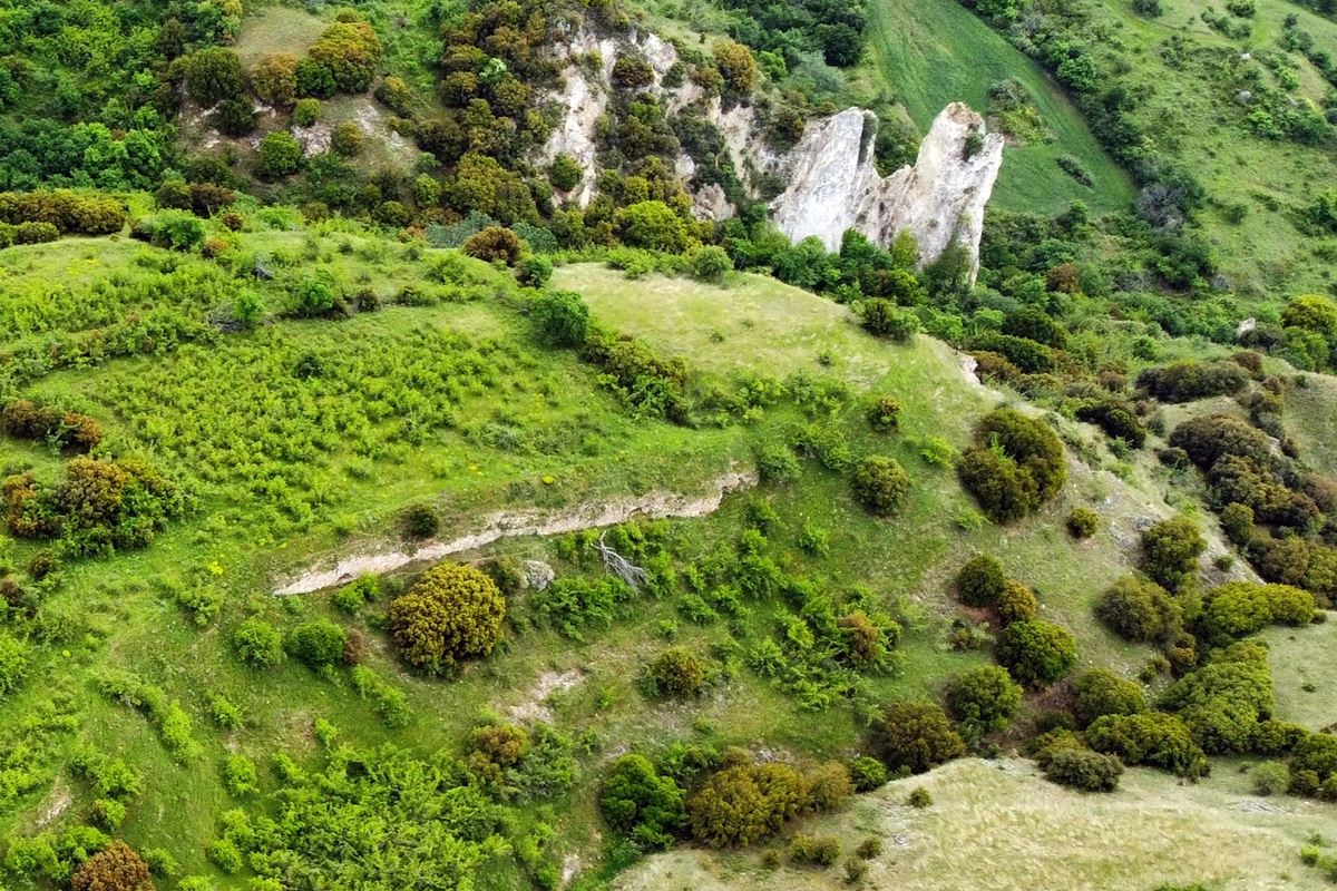
impressive rock formation at the south tedge of the hill
16 / 16

the hill of the castle fro SE

THE END
| Location: |
| On a hill 2.5 km NE of the village Dafnoudi in Serres prefecture, in Central Macedonia |
| Region > Prefecture: |  |
| Central Macedonia Serres | |
| Municipality > Town: | |
| City of Emmanouil Pappas • Dafnoudi | |
| Altitude: | |
|
Elevation ≈ 285 m (Relative Height≈30 m) |
| Time of Construction | Origin | |
| Unknown (not ancient) | Unknown |
|
| Castle Type | Condition | |
| Castle Ruins |
In Ruins
|
Ruins of a castle 2.5 km northeast of the village of Dafnoudi in the prefecture of Serres, on a hill called Kailias or Gailes. The name of the hill is a corruption of the Turkish word “Kale” which means castle.
It is a castle with a settlement from which the ruins of a wall are preserved.
History
Nothing is known about the history of the castle and the settlement. It has not yet been identified with any entity known from historical sources.
The hill has been inhabited since the prehistoric period, as surface pottery of the Late Bronze Age was found.
On a hill called Chavdar Tepe which is located immediately northwest of the castle, there is a necropolis with graves carved into the rock (photo 14) and, around it, ceramics from Roman times. It goes without saying that these tombs are older than the castle.
Ceramics belonging to the Late Roman-Early Christian period were found inside the castle. Consequently, a timeless habitation is observed at the site, from the Hellenistic to the post-Byzantine years.
From the masonry that consists of semi-worked stones with korasani (binding mortar), we can be sure that the castle was built from the Early Byzantine period onwards. In the Archaeological Bulletin of 1967 (issue 22/B2) the hypothesis is that the castle probably dates from the post-Byzantine period (that is, the Tourkokratia).
So the dating of the castle is rather problematic and for now we cannot date it with some acceptable accuracy.
It should be noted that the castle is not in a strategic position. It does not oversee a large area or have optical contact to any neighboring castle. Instead, the location seems to have been chosen so that the castle would not be easily spotted.
Structure, Fortification & Buildings
Two streams flow along the eastern and western slopes of the hill: the Karavik stream and Tsavdar Tepe respectively, which converge under the steep southern side to form the Sari Alum stream, providing natural protection to the castle. On the opposite side, to the north, was the most vulnerable point of the castle, where a small neck forms with the northernmost and slightly higher neighboring hill. A stone-paved road passed through this neck, traces of which are still visible today (photo 11).
The perimeter of the castle is approximately 600 meters enclosing an area of 21 acres.
Visitors from 1994 reported that on the hill were fields with grain crops (P.Samsaris, 2004). Today the fields have been abandoned, and as a result the interior is covered by dense vegetation.
Remains of the fortifications are preserved in several places on the hill. The most characteristic and visible element of the fortification is a continuous wall on the western side, with a total length of about 70 meters and a maximum height of about 3 meters (photos 1,3,4,5). The masonry consists of semi-finished stones of different sizes with binding mortar in the gaps and irregular use of bricks. Several holes can be seen in the walls, possibly for wooden bindings.
There is also a large artificial opening in the wall with dimensions of 0.20✖0.95m. (photo 6), which looks like a porthole or a rifle port (and perhaps because of the shape of this opening it has been assumed to be post-Byzantine).
In the rest of the castle, only fragmentary elements of the fortification are preserved. More specifically:
On the northern vulnerable side there is a section of wall 3 meters high and 2 meters thick (photos 7,8) and another about 10 meters long (photo 9) with a height that does not exceed 1.5m.
In the southern corner there are scattered remains of a wall (photo 10). In the southeast, a geological formation with high vertical rocks is impressive, above the eastern stream (photo 15).
On the steep eastern side, nothing survives and there does not seem to have been a wall. The vertical high rocks formed on this side, combined with the Karavik stream passing below, made it inaccessible to the enemy.
On the plateau of the top of the hill but also along the eastern slope, one can spot building foundations, stone piles, scattered stones, ceramics and roof tiles that make up the ruins of the settlement.
Somewhere in the middle of the eastern craggy side, at a point with vertical rocks, there is a small natural cave (photos 12,13), the approach to which is very difficult.
According to local tradition, the cave communicated through a hidden tunnel with the interior of the castle. The cave and tunnel are supposed to have served the besieged to access the water of the eastern stream (by throwing buckets with ropes or something like that). In general, it was very common in castles to have – whenever possible – a hidden gate or passage to an adjacent river to ensure water supply in conditions of siege. In these cases the water tanks (cisterns) inside either did not exist or were small.
| First entry in Kastrologos: | June 2023 |
Sources
- Research, presentation and photos by Sakis Amfitreidis and his blog ΑΜΦΙΤΡΕΙΔΗΣ (May 2023)
- Σαμσάρης, Πέτρος «Βυζαντινοί τόποι και μνημεία της κάτω κοιλάδας του Στρυμόνα», 2004, Πανεπιστήμιο Ιωαννίνων – Διδακτορική Διατριβή, 2004, σελ. 672-674
- Σαμσάρης,Δημήτριος «Ιστορική γεωγραφία της Ανατολικής Μακεδονίας κατά την αρχαιότητα». Μακεδονικά, 16(1), 1976, σελ. 171-179
- ΑΡΧΑΙΟΛΟΓΙΚΟN ΔΕΛΤΙΟN, τεύχος 22/Β2 (1967), σελ. 427
|
|
| Access |
|---|
| Approach to the monument: |
| At the entrance of the village there is a cross with 3 asphalt roads. Φollow the one on the right. At 2.8 km, at the sign “Εκπαίδευση Σκύλων”, turn right onto a dirt road. After 550m leave the vehicle and after 400m on foot is the castle. |
| Entrance: |
| Free access. Dense vegetation makes it difficult to walk on the hill. |
| Similar |
|---|
| Castle of Achladochori |
| Fortification of Vyssiani |


