

Lefkonas, Sintiki, Serres,Central Macedonia
Fortification of Vyssiani


| Location: |
| Three kilometers north of the village Lefkonas in Serres prefecture, Central Macedonia |
| Region > Prefecture: |  |
| Central Macedonia Serres | |
| Municipality > Town: | |
| City of Sintiki • Lefkonas | |
| Altitude: | |
|
Elevation ≈ 220 m (Relative Height≈10 m) |
| Time of Construction | Origin | |
| perhaps 13th cent. | Late-BYZANTINE |
|
| Castle Type | Condition | |
| Castle Ruins |
In Ruins
|
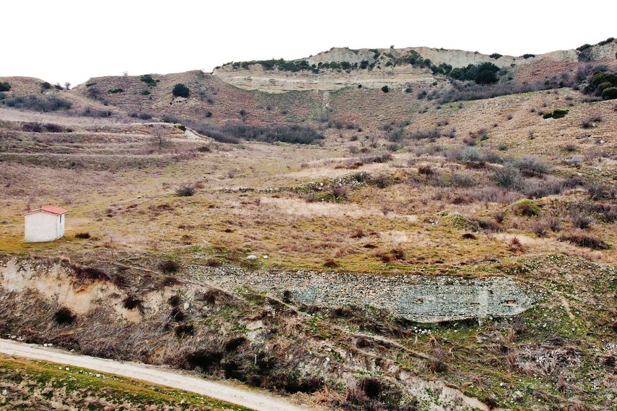
Remains of a 35-meter-long defensive (?) wall that protected a late-Byzantine settlement named Vyssiani, 3 kilometers north of the village of Lefkonas and 10 kilometers from Serres.
Opposite, at 600 meters, is the convent of Panagia Vyssianis. The stream “Megalo Rema” flows between them.
History
In October 1338, Princess Theodora Kantakouzini (1332-1381, daughter of Emperor John V and 5th wife of Sultan Orhan) donated to the monastery of Koutloumoussi possessions in various places among of which was Vyssiani.
This was the first historical reference to Vyssiani, which apparently existed from before, but exactly since when is unknown. It is most likely that it was created in the 13th century without ruling out that it existed since the Middle Byzantine period.
The village is mentioned as Vīsen in an Ottoman census of 1454/55, with a population of 170 inhabitants. It is also mentioned in 1641 in an incident in which a 15-year-old girl died and was buried there in Vyssiani. In 1881-1889 it is reported to have 92 inhabitants, in 1910 there were 80 inhabitants and in the census period of 1912-1915 there were 30 inhabitants. Many online articles state that in 1916 it was completely destroyed by the Bulgarian army. In 1928 it was abandoned.
Therefore, it is a settlement with a lifetime of at least 5 centuries, which in the Late Byzantine period was fortified and then it seems that it lost its fortified character and its original configuration, probably from the period of the Turkokratia. Only a section of the wall (photos 1, 2, 3, 4) remained as a reminder of the late Byzantine past of the settlement.
Structure, Fortification & Buildings
Vyssiani is located on a plateau in an area whose relief consists of sandy hills. The northern, eastern and southern sides of Vyssiana are run by the Megalo Rema, which serves also as a natural moat.
To the west of the stream is a fortified hill with a steep and fragile peak next to which the village of Vyssiani was well hidden. The only thing left today to remind that there was once a settlement here, is the chapel of Agios Dimitrios that was built in 1984 on the site of a much older church.
Just below the chapel, a part of the eastern fortification, about 35 meters long, is preserved. It is a wall with a maximum height of 4 meters built with semi-finished stones of different sizes with binding mortar between them and a few ceramic fragments in the gaps. The site, with its rear completely backfilled, suggests that it could have been a retaining wall instead of a defensive one, although the construction appears more elaborate than would have been necessary for this purpose. On the other hand, we cannot say that this is a representative sample of a Late-Byzantine wall.
The rest of the wall has not been saved, so the boundaries and perimeter of the settlement are not clear.
In the rest of the area, there are some spots with scattered stones and ceramics that are ruins of the buildings of the settlement.
| First entry in Kastrologos: | March 2023 |
Sources
- Info, research and photos by Sakis Amfitreidis and his blog ΑΜΦΙΤΡΕΙΔΗΣ (March 2023)
- Σαμσάρης, Πέτρος «Βυζαντινοί τόποι και μνημεία της κάτω κοιλάδας του Στρυμόνα», 2004, Πανεπιστήμιο Ιωαννίνων – Διδακτορική Διατριβή, 2004, σελ. 716, 231-232
- Website newsbeast - Το «θαύμα» της Παναγίας Βύσσιανης στο Μετόχι
|
|
| Access |
|---|
| Approach to the monument: |
| After the bridge over the Megalo Rema in Lefkonas, follow the road to the north with the stream on the right. At 1300m turn left on an uphill road. After 2km turn right onto a dirt road that after 800m. leads to Vyssiani. |
| Entrance: |
| Free access. |
| Similar |
|---|
| Castle of Achladochori |
| Castle of Dafnoudi |


