

Siderokastro, Sintiki, Serres,Central Macedonia
Castle of Mavros Vrachos
or Castle of Black Rock
1
2 / 14

the hill of the castle
3 / 14

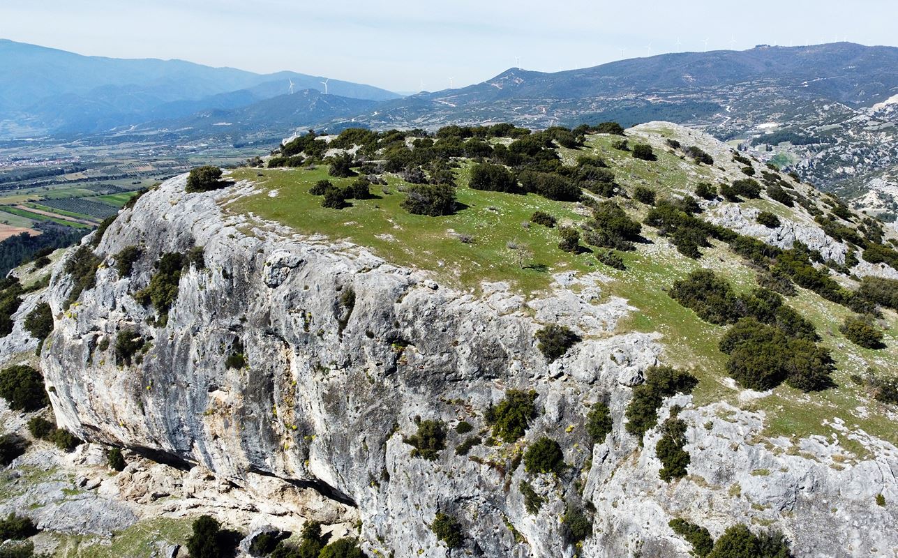
the southeast side of the Rock with the fortification
4 / 14

ruins of the fortification wall
5 / 14

the tower (?) of the wall
6 / 14

remains of the fortification with a protruding tower(?)
7 / 14

remains of the fortification
8 / 14

remains of the fortification
9 / 14

remains of buildings in the interior
10 / 14

the top of the rock
11 / 14

the cavity with the water source
12 / 14

the water in the cavity
13 / 14

view of the Black Rock from Siderokastro
14 / 14

the Black Rock

THE END
| Location: |
| On a rocky o hill 3km northeast of Sidirokastro in Serres prefecture |
| Region > Prefecture: |  |
| Central Macedonia Serres | |
| Municipality > Town: | |
| City of Sintiki • Siderokastro | |
| Altitude: | |
|
Elevation ≈ 360 m (Relative Height≈200 m) |
| Time of Construction | Origin | |
| perhaps early 14th cent. | Late-BYZANTINE |
|
| Castle Type | Condition | |
| Natural Fort |
In Ruins
|
Ruins of a late-Byzantine fortification on a steep hill called Mavros Vrachos (Gr. Black Rock) or Eski Isar (Tr. Old Castle) 3 kilometers northeast of Sidirokastro in Serres prefecture.
Location & Strategic Scope
The place is in an idyllic location with rich vegetation and lots of water.
From the castle of Mavros Vrachos there is 360° visibility of the surrounding area. The visibility reaches up to the mountains of Orvilos, Agistrou, Lailia and Beles.
It overlooks a large part of the plain of Serres. It could survey the passage of the Krousovitis river to the plain of Serres.
On the eastern slopes of the hill flows Krousovitis river. From the foothills of the Black Rock, warm waters flow into Krousovitis, forming impressive waterfalls.
The castle is located at a short distance (less than 4 km) from another fortification with similar features and a similar name, the Faia Petra castle. It also has visual contact with the castle of Sidirokastro (photo 13).
History
The history of the castle is unknown. There is no mention of it from historical sources.
In 2005 the regional Ephorate of Prehistoric and Classical Antiquities conducted research on the site. The findings of this research confirmed an earlier hypothesis that at the foot of the rock there was an important sanctuary of Apollo and Pan which was destroyed by Christians in the 4th AD. century.
Among the others, two natural niches at the entrance of the canyon were investigated, from where remarkable ceramics of the later Neolithic era emerged. At another point, in one of the shallow caves of the rock, a small rough semi-circular wall was revealed that protected the cave with a perimeter of 10.5 meters, 1.20 m high, 0.90 m wide, with traces of fire inside.
This wall, which is not directly related to the castle at the top, dates back to early Christian times and probably belonged to shepherds who at that time used the rock.
At the base of a stone staircase that led to the ancient cult spaces, broken vases, iron knives and many copper coins were found, most of which are of Marcus Aurelius (2nd century) and Constantine the Great (4th century).
The short archaeological survey of 2005 did not deal at all with the castle, that is, with the wall at the top of the rock, which is much younger than the time when the ancient sanctuary was destroyed. In the Archaeological Bulletin of 1988, the fortification of the Black Rock is dated at the same era as the castle of Sidirokastro (beginning of the 14th century). This is not easy to prove, but the type of masonry indeed refers to that period more or less.
To recap, the Black Rock had been inhabited since the later Neolithic period and continued to be inhabited until late antiquity and early Christian times. For the Middle Byzantine period, we have no information, but it probably continued to be inhabited and would certainly have had some fortification which was rebuilt during the Late Byzantine period, perhaps shortly after 1330.
The Ottomans occupied the area in 1383 and logically within the following decades the castle must have been abandoned.
Structure, Fortification & Buildings
The Black Rock is an imposing, prominent rocky hill that got its name from the dark color of its rocks.
The castle occupies the plateau of the peak in an area estimated at 30,000 sq.m. All sides of the castle are steep and therefore not all are fortified. The only passable access point to the summit is a neck formed by an adjacent lower wooded ridge to the southeast of the rock.
At this point there are ruins of a wall that follows the rugged terrain and blocks the entrance to the castle.
Actually, the “fortification” of the castle is a 60-70 meter long rampart on the south-east side with a wall consisting of stones of different sizes, with connecting mortar between them while in places there is a dense use of bricks.
The highest surviving part of the wall is 1.80 m high, while the thickness varies from 1.30 to 1.50 m. On the right side of the wall there was a tower 4.20✖4.5 m. (photo 5) and we assume that there was the gate. A little higher there is a projection of the wall measuring 1.2✖5.5 meters (which may also have been a tower, photo 6).
At the top of the Black Rock, i.e. inside the castle, a plateau is formed, where stone piles, foundations of buildings and scattered stones with ceramics can be seen (photo 9). Apparently these are the remains of the Byzantine settlement.
It is worth mentioning that at a distance of a few meters from the top, a hole is formed in the ground which at its depth ends in a niche with water (photos 11,12). It is a natural hollow with dimensions of approximately 2.0✖1.5 meters, in which there is water.
It is said that water always springs up in this natural cistern and has a constant level throughout the year, even in a period of great drought. The existence of this inexhaustible source was certainly a great asset to the castle. In this niche, among the many stones inside, two small fragments of ancient columns were found.
| First entry in Kastrologos: | April 2023 |
Sources
- Info, research and photos by Sakis Amfitreidis and his blog ΑΜΦΙΤΡΕΙΔΗΣ (March 2023)
- Σαμσάρης, Πέτρος «Βυζαντινοί τόποι και μνημεία της κάτω κοιλάδας του Στρυμόνα», 2004, Πανεπιστήμιο Ιωαννίνων – Διδακτορική Διατριβή, 2004, σελ. 710, σχέδιο 105
- ΔΗΜΟΣ ΣΙΝΤΙΚΗΣ: - Ο χώρος και η ιστορία του-2013-(Ειδική έκδοση για τα 100 χρόνια από την απελευθέρωση του Δήμου Σιντικής)-σελίδες 170 & 156.
- Ελευθέριος Ελευθεριάδης, Αποδεικτικά στοιχεία της ύπαρξης μεγάλου σπηλαίου και Νυμφαίου Απόλλωνα στα έγκατα του Μαύρου Βράχου, σελ.16-17. περισσότερα εδώ
- Ελευθέριος Ελευθεριάδης, Φως στα μυστικά του Μαύρου Βράχου, σελ. 34-35
- Σταυρούλα Δαδάκη, ΑΡΧΑΙΟΛΟΓΙΚΟΝ ΔΕΛΤΙΟΝ, τεύχος 43/Β2 – 1988, σελ.447 και πιν. 265γ
- Κ.Περιστέρη, Β.Χαλκιοπούλου, ΠΡΩΤΗ ΑΝΑΣΚΑΦΙΚΗ ΕΡΕΥΝΑ ΣΤΟ ΣΙΔΗΡΟΚΑΣΤΡΟ ΣΤΗ ΘΕΣΗ «ΜΑΥΡΟΣ ΒΡΑΧΟΣ» ΚΑΤΑ ΤΟ 2005, Το Αρχαιολογικό Έργο σε Μακεδονία και Θράκη (ΑΕΜΘ), τεύχος 19, Θεσσαλονίκη 2007, σελ. 129-134
|
|
| Access |
|---|
| Approach to the monument: |
| 2 km after Sidirokastro towards Achladochori there is a sign “Amanatidi Pools.” At 150m in this direction there is a sheepcote and a fork. We turn right and after 800m at a new fork on the left. After 1.5 km we reach below the castle. |
| Entrance: |
| Free access. |


