

Achladochori, Serres, East Macedonia & Thrace
Castle of Krousovitis


| Location: |
| On a hill at the southern bank of Koursovitis river, 1.5 km south of Achladochori, in Serres prefecture |
| Region > Prefecture: |  |
| East Macedonia & Thrace Serres | |
| Municipality > Town: | |
| City of Serres • Achladochori | |
| Altitude: | |
|
Elevation ≈ 488 m (Relative Height≈30 m) |
| Time of Construction | Origin | |
| 3rd or 4th cent. AD | Early ΒΥΖΑΝΤΙΝΕ |
|
| Castle Type | Condition | |
| Castle Ruins |
Few Remains
|
Minor traces of fortification on a hill named "Altsoua Koula" one and a half kilometers southeast of the village of Achladochori in the prefecture of Serres.
These are the remains of a strong fortification of an unknown castle, on the south bank of the Krousovitis river. Traces of a prehistoric settlement from the Neolithic period were also found on the hill.
Location & Strategic Scope
The castle is located on a plateau at the top of a trapezoidal hill. On the northern slopes of the hill, at a distance of 100 meters, flows the waters of the Krousovitis river, while on the southern and western slopes the waters flow two streams, offering natural protection on its three sides. The smooth eastern side was the most vulnerable point of the castle, from which the hill was accessed through a small neck formed in the ground by the adjacent hill.
From the castle there was visibility over a large part of the valley of the Krousovitis river and the surrounding mountains (Orvilos, Vrontou, Agistro).
History
The history of the castle is unknown. Nothing relevant has been found in historical sources. On the hill, sherds of vases and remains of clay utensils, as well as finds of tool equipment from the prehistoric period, have been found. According to the Archaeological Bulletin 50-B'2, p. 637, a prehistoric and historic settlement was located on Altsua Kula hill. The surface hand-made pottery belongs to the latest and final Neolithic period (5300-3000 BC)
Several centuries later, in historic times, there was a new settlement on the hill. The fortification with a rubble-masonry wall and strong lime mortar belongs to this period. The use of lime mortar in masonry takes us chronologically from the 3rd-4th century AD. and after. Another castle of the same era is located 3 km northeast of Achladochori at the location of Grandista.
Like other unknown ruined settlements and castles in Northern Greece, the castle at the Altsoua Kula site should not, logically, have survived the barbarian raids of the 5th century or, at the latest, the 7th century (Avars-Slavs). It is most likely that the castle was abandoned before the middle of the 5th century, when the Huns, with successive invasions, had ravaged Thrace and Macedonia.
Structure, Fortification & Buildings
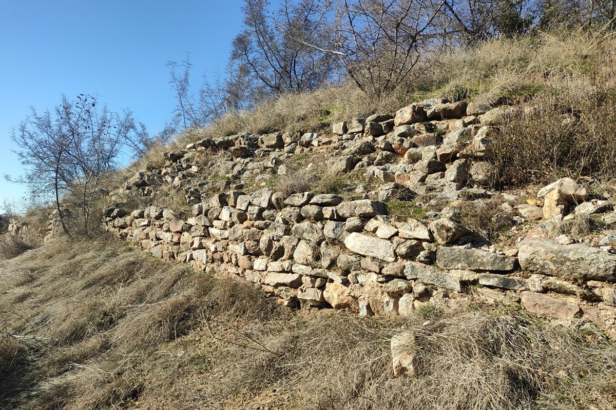
The castle had a perimeter of about 200m. Along the entire length of this perimeter there seems to have been a wall, of which few ruins survive today.
The masonry consists of stones with binding mortar. The best preserved part of the wall is located along the south-southeast side (photos 4,5). It is a wall 40 meters long with a height ranging from 1-1.5 meters. The thickness of the wall was at least 1.30m.
Traces of a wall are also present on the west side and in the north-west corner. On the far north side, dense scrub vegetation has completely covered the wall.
The top of the hill is flattened. Few surface ceramics and scattered stones bear witness to human settlement on the hill which is now covered with vegetation. 150 meters north of the castle, a double-arched stone bridge is preserved over the Krousovitis river (photo 6), from which the hill can be accessed.
It is worth mentioning that along the Krousovitis river, during the Turkokratia, there was a stone-paved road with many bridges that connected the villages of Karydochori and Achladochori with Sidirokastro. Many of these bridges are still standing. 150 meters north of the castle the bridge of Agia Kyriaki (Kato Belitsa) is preserved. It should be mentioned that this road was cobbled and preserved in good condition when Samsaris visited it in 1995. Today, traces of this cobbled road can hardly be seen. Without a doubt these cobbled streets were built on traces of older roads.
| First entry in Kastrologos: | April 2024 |
Sources
- Presentation, research and photos by Sakis Amfitreidis and his blog ΑΜΦΙΤΡΕΙΔΗΣ (December 2023)
- Σαμσάρης, Πέτρος «Βυζαντινοί τόποι και μνημεία της κάτω κοιλάδας του Στρυμόνα», 2004, Πανεπιστήμιο Ιωαννίνων – Διδακτορική Διατριβή, σελ.354
- Σαμσάρης, Πέτρος, «Νέος νεολιθικός οικισμός στο Αχλαδοχώρι Σιντικής», Περιοδ. «Σίρις» τόμ. 5 (Σέρρες, 1995-96) σσ. 17-32 , και online
- ΑΡΧΑΙΟΛΟΓΙΚΟΝ ΔΕΛΤΙΟΝ, τεύχος 50/Β’2 (1995), σελ.637, Μ. Βάλλα
|
|
| Access |
|---|
| Approach to the monument: |
| South of Achladochori begins a rough dirt road of 1 kilometer that leads to the stone bridge of St. Kyriaki (there are road signs). From there we follow a 50m path towards the eastern side of the hill. |
| Entrance: |
| Free access. |


