

Oinoussa, Serres, Central Macedonia
Castle of Oinoussa
1
2 / 11

the plateau of the top and, right, the eastern neck
3 / 11

ruins of eastern wall (15m long, 1.5m high)
4 / 11

ruins of eastern wall (15m long, 1.5m high)
5 / 11

wall remains of the nother side (h: 0.8m)
6 / 11

remains of a wall at the eastern slope
7 / 11

few wall remains at the south side
8 / 11

building foundations ath the south slope
9 / 11

the picture of the virgin engraved on the rock
10 / 11

the hill from the north, the cave and the gorge of Kokinorema
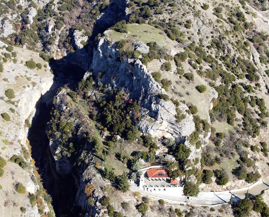
11 / 11

the hill from the north, the cave and the gorge of Kokinorema

THE END
| Location: |
| On the plateau of a steep hill 0.5 km north of the village Oinoussa of Serres prefecture |
| Region > Prefecture: |  |
| Central Macedonia Serres | |
| Municipality > Town: | |
| City of Serres • Oinoussa | |
| Altitude: | |
|
Elevation ≈ 190 m (Relative Height≈70 m) |
| Time of Construction | Origin | |
| perhaps 3rd or 4th cent. | Early ΒΥΖΑΝΤΙΝΕ |
|
| Castle Type | Condition | |
| Castle Ruins |
In Ruins
|
A few ruins of a fortification and an old settlement on the plateau of the top of a steep hill called “Vlaselniko”, half a kilometer north of the village of Oinoussa, at the northeastern end of the prefecture of Serres.
History
The history of the castle is not known. It is believed that there was originally a Roman fortress and a Roman necropolis on the hill (Samsaris, 2004).
The beginning of the use of lime mortar in masonry can be dated from the 3rd-4th century AD. This, combined with the surface pottery of the Early Christian period found in the area, leads us to conclude, with reservations, that the castle belongs to the Early Byzantine Period.
There are several similar fortified settlements (castles) in this area (at the foot of Menoikiοn mountain). Examples are the castles of Chionochori, Neo Souli and Agio Pneuma. All these Early-Byzantine fortified settlements were abandoned by the 7th century, at the latest.
Structure, Fortification & Buildings
The top of the hill is at an altitude of 190 meters. At the base of the rock, in the location of Faneromeni, there is the modern chapel of the Dormition of the Virgin and right next to it a deep gorge is formed by the waters of the riven Kokkinorema. The hill is the last rocky elevation before the exit of the gorge.
The top of the hill is flat and mostly surrounded by vertical limestone cliffs that made it inaccessible. The fortified eastern side was the most vulnerable point of the castle. A narrow neck separates the elevation from the descending mountainside. The hill belongs to the range of the Menoikion mountain.
The perimeter of the castle at the top is 150-160 meters. A fortification of a continuous wall 80 meters long blocked the entrance to the vulnerable eastern side. This wall is in a dilapidated state, since most of it has been scattered on the steep slopes. But his traces are evident along the entire length of its course. It is a wall made of stones with white binding mortar between the stones. The best-preserved part of the wall has a length of 15 meters and a maximum height of up to 1.5 meters (photo 3, 4).
The summit plateau is full of scattered stones and pottery fragments. Outside the wall and along the steep southern slope, building foundations and building remains can also be seen (photos 6, 8). All of these appear to be remnants of an unknown fortified settlement that existed inside and outside the wall. Some burials can also be seen on the southern slope.
At the southwestern foot of the rock, in the “Faneromeni” position, is the chapel of the Dormition of the Virgin (photo 1). An interesting Byzantine rock painting is preserved on the vertical rock behind the church (photo 8). It is a hagiography that represents the Virgin Mary holding Christ in her arms, while on the left and right there are archangels. Next to it, is preserved an inscription dated 1382.
A large cave located at the northwestern root of the hill, which is called asketotrypa (photo 10, 11) also makes an impression. It is one of the many rock caves formed in the vertical cliffs of the gorge, which were used as a hermitage by monks of the historic Timios Prodromos Monastery located 3.5 km further north.
| First entry in Kastrologos: | December 2023 |
Sources
- Research, presentation and photos by Sakis Amfitreidis and his blog ΑΜΦΙΤΡΕΙΔΗΣ (December 2023)
- Σαμσάρης, Πέτρος «Βυζαντινοί τόποι και μνημεία της κάτω κοιλάδας του Στρυμόνα», 2004, Πανεπιστήμιο Ιωαννίνων – Διδακτορική Διατριβή, 2004, σελ. 694-699 & 622-625
- «Άγνωστη βυζαντινή τοιχογραφία στην περιοχή των Σερρών», σελίδα 399 (Ανάτυπο από Εταιρία Μακεδονικών Σπουδών).
|
|
| Access |
|---|
| Approach to the monument: |
| A 600m dirt road north of Oinousa leads to the foot of the rock. (There are signs to the church.) From the church continue on foot in a short but difficult hike. |
| Entrance: |
| Free access. The hike is very difficult dew to vegetation |


