

Chionochory, Serres, Central Macedonia
Castle of Chionochori
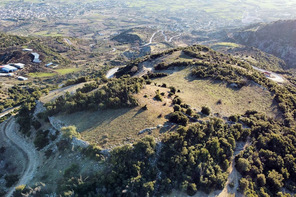
1
2 / 12

the citadel
3 / 12

wall of the citadel
4 / 12

part of the east wall
5 / 12

part of the east wall at the citadel section
6 / 12

part of the south wall
7 / 12

part of the south wall
8 / 12

traces of the west wall
9 / 12

the citadel
10 / 12

vue to the city of Serres
11 / 12

dry stone walls inside the castle, made of its ruins
12 / 12

the hill of the castle from the road

THE END
| Location: |
| On the hill “Koulia” 1km SW of the village Chionochori in Serres prefecture, Central Macedonia |
| Region > Prefecture: |  |
| Central Macedonia Serres | |
| Municipality > Town: | |
| City of Serres • Chionochory | |
| Altitude: | |
|
Elevation ≈ 540 m (Relative Height≈40 m) |
| Time of Construction | Origin | |
| Unknown | Early ΒΥΖΑΝΤΙΝΕ |
|
| Castle Type | Condition | |
| Castle Ruins |
In Ruins
|
Ruins of a large castle on the plateau of an elevation called “Koulia”, one kilometer southwest of the village of Chionochori, north of Serres, on a spur of the Menoiki mountain.
History
The history of the castle is unknown. The relatively large area within the walls shows that it was not just a military fortress, but a fortified settlement. It has not been identified with any of the settlements known from historical sources.
Unpainted ceramics from the Late Roman and Early Christian periods were found in the area (Samsaris, 2006) and for this reason the castle is chronologically placed in the Early Byzantine Period.
The existence of the settlement is probably related to the exploitation of iron and marble deposits in the surrounding area, which seems to have started from the Roman period.
Like other unknown and spacious settlements in Northern Greece, the settlement of Chionochori should not, logically, have survived the barbarian raids of the 5th century (e.g. Huns) or, at the latest, the 7th century (Avars-Slavs).
To sum up, and according to the available info, the castle-settlement at Chionochori existed approximately from the 3rd century and ceased to be inhabited, at the latest, at the end of the 7th century.
Structure, Fortification & Buildings
It is a relatively large castle with a perimeter of fortifications of 590 meters covering an area of approximately 18,000 sq.m..
The fortified settlement spreads out on a slope of the Menoiki mountain at an altitude ranging from 480, in the southwest, to 540 meters, in the northeast. All its slopes are rather steep offering rudimentary natural defensive protection, except for the northern side which is separated by a smooth neck with the descending slope.
The fortification had a polygonal plan and the wall followed the terrain. The masonry consists of semi-finished stones of various sizes with binding mortar.
At the north-eastern edge of the castle there is a citadel (photo 2) which is separated from the rest of the settlement by a separate fortification.
In the citadel, a wall is preserved that reaches up to 2.5 meters with a thickness of 1.30m (photo 3.5). The foundations of a rectangular tower with dimensions of 4✖5m in the north-east corner are also preserved.
In the rest of the castle, the best surviving walls are on the east side. They are preserved in a height that reaches up to 3 meters and a thickness of 1 meter.
On the south side, a continuous horizontal wall 100 meters long with a height reaching up to 2 meters is preserved (photo 7).
On the western side, the wall is destroyed and can only be traced at the level of the foundations in some places (photo 8).
In the interior there are scattered ceramics. Also within the castle are later dry-stone constructions (photo 11) that were probably built by local herders.
From the castle there is a wide field of vision to the south and to the plain of Serres. The visibility reaches from Pangaeo to the Krusia Mountains opposite, having visual contact with the acropolis of Serres as well.
| First entry in Kastrologos: | February 2023 |
Sources
- Info and photos by Sakis Amfitreidis and his blog ΑΜΦΙΤΡΕΙΔΗΣ (February 2023)
- Σαμσάρης, Πέτρος «Βυζαντινοί τόποι και μνημεία της κάτω κοιλάδας του Στρυμόνα», 2004, Πανεπιστήμιο Ιωαννίνων – Διδακτορική Διατριβή, 2004, σελ. 716, 717
|
|
| Access |
|---|
| Approach to the monument: |
| On the Oinouson-Chionochori provincial road, turn left onto a dirt road 2km before Chiononochori, which in 100m leads to the eastern wall of the castle. |
| Entrance: |
| Free access. |
| Similar |
|---|
| Castle of Agio Pneuma |
| Castle of Kalokastro |


