

Kelidi, Sindiki, Serres,Central Macedonia
Tower of Roupel


| Location: |
| On a hill south of the Roupel fort, on the national road towards the Greek-Bulgarian border |
| Region > Prefecture: |  |
| Central Macedonia Serres | |
| Municipality > Town: | |
| City of Sindiki • Kelidi | |
| Altitude: | |
|
Elevation ≈ 85 m (Relative Height≈30 m) |
| Time of Construction | Origin | |
| Unknown | BYZANTINE |
|
| Castle Type | Condition | |
| Ruined Tower |
Few Remains
|
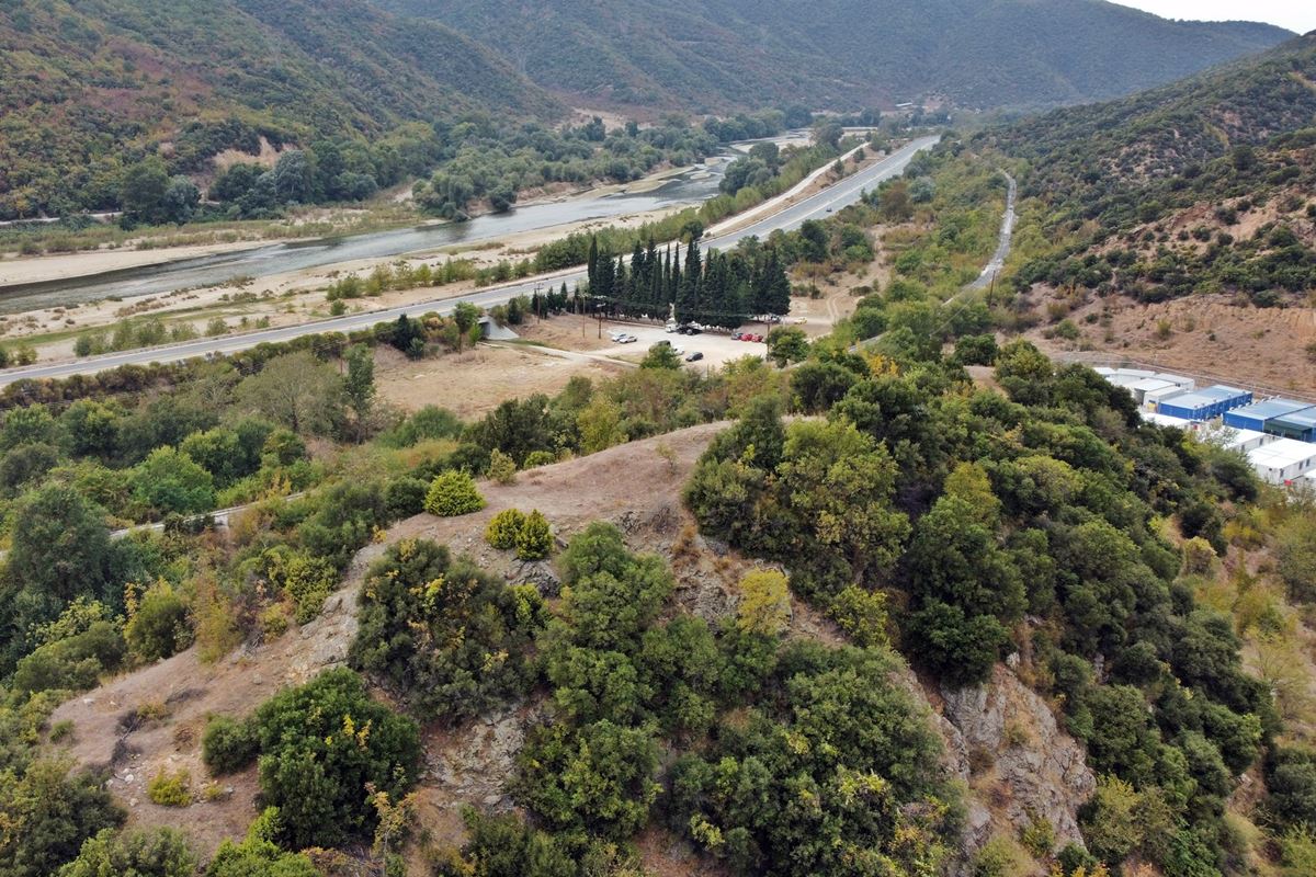
Along the Rupel pass – a passage of strategic importance at the northern end of the prefecture of Serres – two fortified positions of the Byzantine Period have been found. One of them is the ruins of a tower on a hill above the abandoned village of Kleidi, the old name of which was Rupel.
Location & Strategic Scope
The hill of the tower is located just above the abandoned settlement of Kleidi on the eastern side of Strymonas, roughly in the middle of the Rupel pass. The river bed is about 300 meters west of the tower.
Very close to the hill – 3 kilometers to the north-east – is the Rupel fort of the Metaxa Defense Line, which heroically resisted the German invasion in WW II (April 6-10, 1941).
The Rupel pass is 9-10 kilometers long. Its southern entrance is located between the villages of Thermopigi and Petritsiou and the northern one a little south of the village of Promakhon and the border with Bulgaria. The pass is formed between the mountains of Belles and Agkistro..
In Byzantine times, the strait was one of the most important passageways from the Balkan hinterland to Macedonia and the plain of Serres, connecting two important Byzantine cities: Serres and Meleniko (present-day Melnik, Bulgaria).

Earlier, during Late Antiquity, the Rupel pass was part of a Roman road between two ancient cities that were also Roman stations according to the Peutingerian Table (Tabula Peutingeriana – a medieval copy of an ancient road map network of the Roman Empire). These are the cities of Skotoussa (which was in the Palaiokastro-Siderokastro – not identified) and Heraklia of Sintiki (near the present-day village of Rupite in Bulgaria).
Strabo mentions the straits of Rupel without naming them (Geographic VII, excerpt 36).
We must point out that during the Byzantine era the crossing of the passage did not follow the current riverside route, but from the outskirts of Sidirokastro it approached the fortress of Thermopigi and between the low hills of Agkistron on the eastern side of the Strymon river reached Kleidion (Roupelion/Rupepl). From there it continued to Melenikon. The reason for this strange route was that Strymon in those years had much more water and was much wider, leaving little room for crossings parallel to the river. In fact, it is reported that the narrowest point in the passage of Rupel had an opening of just 3 meters!
The Name of the Castle
Around the hill of the tower there was a village called Roupelion or Ropeli or Roupeli and finally Roupel, which was renamed Kleidi in 1926.
The renaming was apparently done in memory of the famous Battle of Kleidion of 1014 in which the Byzantines under Basil II the Bulgarian Slayer crushed the Bulgarians.
 A little further down the hill, on the road there is also a monument dedicated to the battle of Kleidion. However, the real location of this battle and the original Kleidion is much further, about 30 km northwest, near the village of Kliuch (=Key) in Bulgaria (where of course it was not possible to set up a Greek victory trophy).
The renaming from Rupel to Kleidi was in our opinion incorrect, because the historical Kleidion was elsewhere and moreover because Rupel was a name that existed from Byzantium and is referred to as Rupelion in Byzantine history books (see below).
The name Rupel is the Turkish rendering of the Byzantine Rupelion. The Byzantine name probably comes from the Latin rupes which means "steep rocks". There is also the possibility that it comes from the Slavic "rupa" which means hole or opening, which is possible since after the 7th century Slavs, the so-called Strymonites or Strumian Slavs, had settled around river Strymon.
History
The tower must have been Byzantine, but we do not know anything about its history or the date of its construction.
The top historical event for the region was the Battle of Kleidion, in 1014, as mentioned above.
Later, in 1255 we have the first historical reference of the pass under the name Rupeliou dyschoria in the account of the battle that took place inside the straits, again between Byzantines and Bulgarians. Specifically, the Bulgarians led by Dragan (or Dragotas - general of tsar Michael II Assen) fortified the pass to prevent the Byzantine troops of the emperor Theodoros II Duke Laskaris (1254-1258). The battle ended with a victory for the Byzantines who surrounded the Bulgarians and forced them to flee (Georgios Akropolites, Chronical Writing, Excerpt 58 ).
So from the Late Byzantine Period, at least, there was a Byzantine village called “Rupelion” or something like that, which was preserved, and 2 centuries later, in an Ottoman tax register of 1454/5 it is recorded as “Rupel” with a population of 105 inhabitants.
The point where the Kleidi (Rupel) is located is also identified with Markoskala or Skala Markou Krali. Prince Marko was a local ruler and is considered a national hero of Serbs and South Slavs. In theory (de jure) he was king (kralis) of Serbia in the period 1371-1395, but in reality he was a vassal of the Turks and a simple local ruler based in Prilep. It is said that he died at this point.
Structure, Fortification & Buildings
It is a rectangular Byzantine tower with dimensions of approximately 8✖3 meters, of which little remains today.
From the village of Kleidi, all that remains is the church of Agios Dimitrios, which is located at the northwestern root of the hill. This church was rebuilt in the period 1930-1940. A Byzantine church probably existed in its place.
In an earlier study (Toloudis, 1982) the ruins are referred to as a Byzantine fortress complex. Samsaris Petros who visited the site in 1994 mentions the existence of only one tower with dimensions of 3.50×8.40m, thickness 0.80m and a maximum height of 1.20m.
Today, the situation is different since only a small part is preserved at the height of the foundations of the western side and the rest has been covered by vegetation.
Looking at the relief of the ground, it is clear that here there was a rectangular building that collapsed.
From an on-site survey of the rest of the hill (Amfitreidis, 2023) no trace of any additional fortification was found.
| First entry in Kastrologos: | November 2023 |
Sources
- Research, presentation and photos by Sakis Amfitreidis and his blog ΑΜΦΙΤΡΕΙΔΗΣ (October 2023)
- Σαμσάρης, Πέτρος «Βυζαντινοί τόποι και μνημεία της κάτω κοιλάδας του Στρυμόνα», 2004, Πανεπιστήμιο Ιωαννίνων – Διδακτορική Διατριβή, 2004, σελ. 496-499
- Σαμσάρης,Δημήτριος «Ιστορική γεωγραφία της Ανατολικής Μακεδονίας κατά την αρχαιότητα». Μακεδονικά, 16(1), 1976, σελ. 50-51, σχόλιο 4
- Τολούδη Άννα, «ΣΙΝΤΙΚΗ, Ιστορία και παραδόσεις» (Έκδοση εκπολιτιστικού-λαογραφικού συλλόγου Σιδηροκάστρου), Σιδηρόκαστρο 1983. σελ. 15.
|
|
| Access |
|---|
| Approach to the monument: |
| The abandoned settlement is next to the national road. The church of Agios Dimitrios is easy to spot. Directly above is the tower. Access is from the south side of the hill via a dirt road. It takes a 5' hike to the top. |
| Entrance: |
| Free access |


