

Agkistro, Sintiki, Serres,Central Macedonia
Castle of Agkistron
1
2 / 15

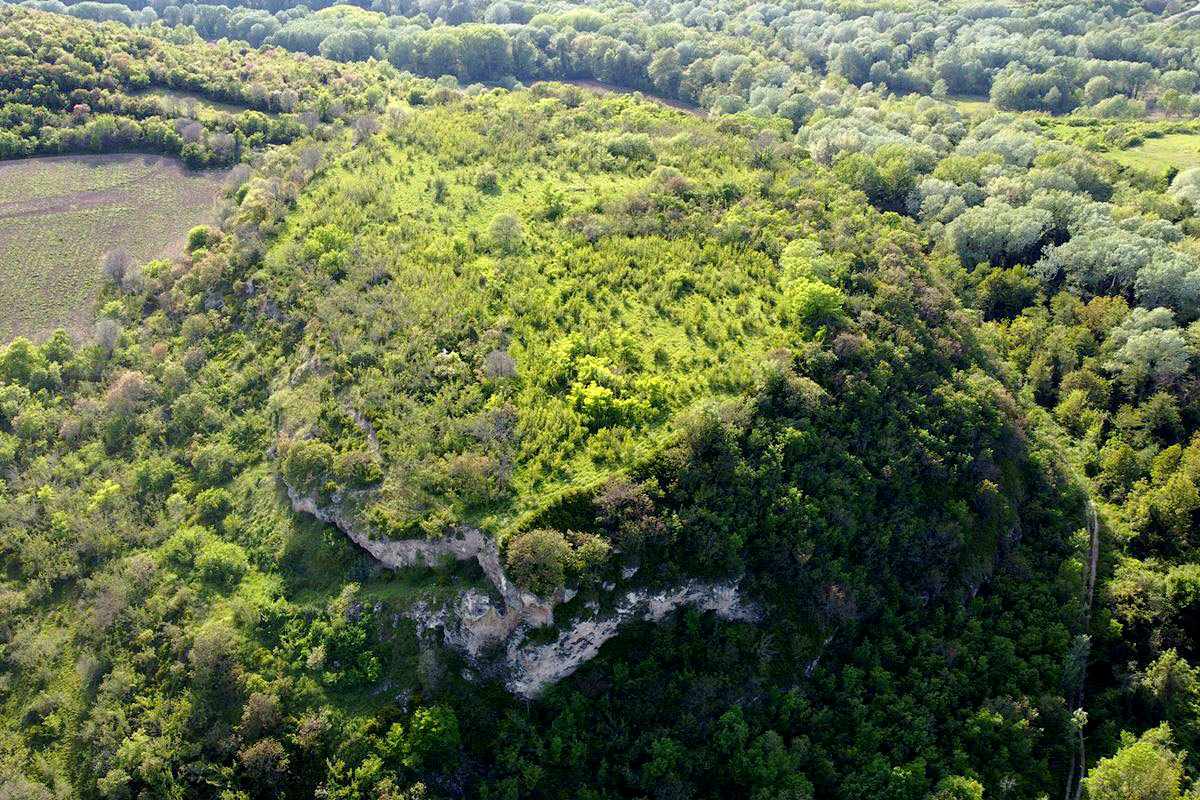
the hill of the castle
3 / 15

the hill of the castle from the west
4 / 15

remains of the south tower
5 / 15

remains of the south tower
6 / 15

remains of the south tower
7 / 15

remains of the southeastern tower
8 / 15

detail of the wall with double layer of bricks
9 / 15

part of the wall of the south side
10 / 15

part of the wall of the southεαστεν side (2m high)
11 / 15

part of the wall of the southεαστεν side (2-3.5m high)
12 / 15

part of the wall of the southεαστεν side
13 / 15

ruins of some building inside
14 / 15

an opening under the wall of the eastern corner
15 / 15

an opening that might have been the entrance (ruins aside)

THE END
| Location: |
| On a hill 3.5 km NW of the village Agkistro in Serres prefecture, Central Macedonia |
| Region > Prefecture: |  |
| Central Macedonia Serres | |
| Municipality > Town: | |
| City of Sintiki • Agkistro | |
| Altitude: | |
|
Elevation ≈ 160 m (Relative Height≈45 m) |
| Time of Construction | Origin | |
| perhaps 4th-5th cent. | Early ΒΥΖΑΝΤΙΝΕ |
|
| Castle Type | Condition | |
| Castle Ruins |
In Ruins
|
Remains of a castle and a fortified settlement on a flattened hill with the name Trapezoides, 3.5 km northwest of the village of Agkistro in the prefecture of Serres.
The hill is located almost on the Greek-Bulgarian border. On the northern side of the hill flows the river Bistritsa, which forms the natural border with Bulgaria.
The name “Trapezoid” is a modern toponym and was given to the hill because of its shape. Formerly it was named Subashi.
History
We know nothing about the history of this castle, which has not been identified with any in the historical sources. According to the Archaeological Bulletin (issue 56-59), on the hill “surface pottery of all eras, starting from prehistoric times and reaching post-Byzantine times, is recognized. On the southern side of the hill, a Byzantine-era fortified enclosure is visible, built with small stones and powerful mortar (kurasani). The surface finds are also spread on the smooth slope south of the hill”.
Consequently, the settlement has a timeless use, while the construction of the fortification (which is certainly not ancient but not Late-Byzantine either) could be placed in the early Byzantine period, a time when Northern Greece faced many troubles from raids by barbarians (Huns, Goths, Slavs, etc.) as a result of which many settlements were fortified with walls and turned into castles to be able to defend themselves. However, the surface finds show that it continued to be inhabited even after the early Byzantine period and there must have been a significant settlement since the few remains reveal a rather strong fortification.
Strategically, we must point out that the castle was located near the Rupel Strait (7 km NE), which has always been a particularly strategic and critical point and passage for all kinds of enemies to Byzantine territory.
Structure, Fortification & Buildings
The top of the hill is a plateau with a relatively large area of 27,000 sq.m. All its sides are steep. On the northern slopes of the hill flow the waters of the Bistritsa river. At the foot of the eastern slope there is a small stream that flows into the Bistritsa river.
Samsaris Petros, who visited the hill in 1989, reports that its flat top was cultivated with grain. Today it seems that the area has been abandoned, since it has been covered by small trees and scrubby vegetation.
Today, few ruins survive from the castle wall. The initial perimeter is estimated at approximately 700 meters. The wall followed the rugged terrain. Although the greater part of the wall has been covered by vegetation or has fallen on the steep slopes, traces of its course are evident.
The construction of the wall consists of layers of semi-worked stones with binding mortar between them and the use of bricks. The thickness of the wall ranges from 1.5 to 2 meters.
Its ruins are today visible on the south and east sides where the remains of two rectangular towers are also found.
The best preserved part of the wall is on the south side. It is a wall with a length of about 20m and a height that reaches up to 4m. In the middle are the ruins of a rectangular tower with dimensions of 6✖3.5 meters (photos 4-6). In its construction, bricks are used in a double row (photo 8). On the south side, fragments and other parts of the wall are preserved (photo 9).
On the southeast-east side there are several wall ruins at a height of 2 to 3m (photos 10-12). There are also remains of a tower (photo 7) with dimensions of 4.0✖2.5m.
On the northern side flows the deep stream of Bistrica. The wall on this side has been covered by dense vegetation and only in a few places some stone piles are indistinctly visible. The same situation, as far as the wall is concerned, also prevails on the western steep side.
On the south-west side of the hill, it is probable that the gate of the castle was located (photo 15). The access to the hill is through this point even today (indeed there are remains of a wall on the side of the road). It is possible that there was also a second entrance near the eastern corner.
On the steep and eroded slopes of the castle, there are several openings in the rocks, like caves (photo 14). The local tradition mentions the existence of underground carved galleries under the hill.
Inside the wall scattered stones, concentrated stone piles and ceramics are observed. In an earlier investigation (Samsaris, 2004), the existence of several scattered architectural marble members from an early Christian church as well as remains from a small single-aisled post-Byzantine church of Agios Georgios located somewhere on the northern slope of the hill is mentioned.
Very close to the castle, 700m. to the southwest, was the settlement of Kato Karydia (old name Brankovo or Branko Tsiflik), of which the only thing that survives today is the renovated church of Agios Athanasios
Agistro castle is located in a hilly area with many ravines and an open horizonto the surrounding area. It has visual contact with all the mountains that enclose the area, such as Beles, Mount Agistro, Orvelos and a large part of the Pirin range (or Eastern Orvelos mountain range) from the Bulgarian side.
| First entry in Kastrologos: | June 2023 |
Sources
- Research, presentation and photos by Sakis Amfitreidis and his blog ΑΜΦΙΤΡΕΙΔΗΣ (May 2023)
- Σαμσάρης, Πέτρος «Βυζαντινοί τόποι και μνημεία της κάτω κοιλάδας του Στρυμόνα», 2004, Πανεπιστήμιο Ιωαννίνων – Διδακτορική Διατριβή, 2004, σελ. 657-658
- Μαγδαληνή Βάλλα. ΑΡΧΑΙΟΛΟΓΙΚΟΝ ΔΕΛΤΙΟΝ, τεύχος 56-59/Β3-β’ (2001-2004), σελ.702
- ΔΗΜΟΣ ΣΙΝΤΙΚΗΣ: - Ο χώρος και η ιστορία του-2013-(Ειδική έκδοση για τα 100 χρόνια από την απελευθέρωση του Δήμου Σιντικής)-σελ.167
|
|
| Access |
|---|
| Approach to the monument: |
| 4.5km after Promachon towards Agistro, a sign shows Agios Athanasios. On this dirt road after 1.5 km we reach the church of Ag. Athanasios and then 550m to the church of St. Paraskevi. There turn left onto another dirt road for 100m. |
| Entrance: |
| Free but difficult access. The dirt roads are rather rough for a conventional car. In the interior, the dense vegetation on a large part of the top makes visiting difficult. |


