

Achladochori, Serres, Central Macedonia
Castle of Achladochori
1
2 / 13

the hill of the castle named “Grandista”
3 / 13

the hill of the castle with mnt Orvilos in the background
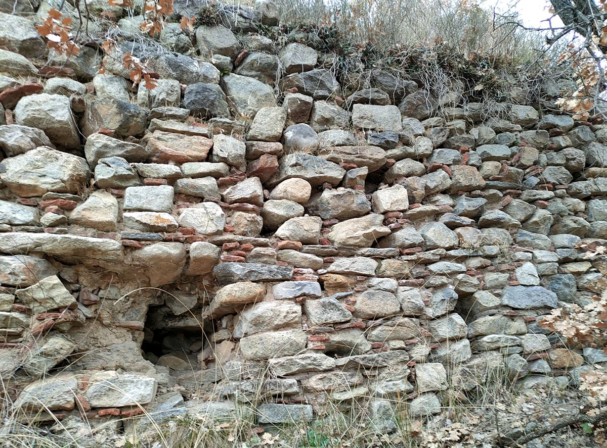
4 / 13

part of SE wall
5 / 13

part of SW wall
6 / 13

part of ΝE wall
7 / 13

part of ΝΕ wall
8 / 13

low, dry-stone wall at the SE side
9 / 13

part of ΝΕ wall built in two phases
10 / 13

dry-stone wall in the interior
11 / 13

foundations of the tower (?) at the top
12 / 13

remains of the dry-stone building in the interior
13 / 13

the hill of the castle

THE END
| Location: |
| On a hill named Grandista, 3km NE of the village Achladochori in Serres prefecture, Central Macedonia |
| Region > Prefecture: |  |
| Central Macedonia Serres | |
| Municipality > Town: | |
| City of Serres • Achladochori | |
| Altitude: | |
|
Elevation ≈ 740 m (Relative Height≈30 m) |
| Time of Construction | Origin | |
| 3rd or 4th cent. CE | Early ΒΥΖΑΝΤΙΝΕ |
|
| Castle Type | Condition | |
| Castle Ruins |
In Ruins
|
Remains of a large fortified settlement of the Roman to Early-Byzantine period on the “Grandista” hill, 3 kilometers northeast of Achladochori in Serres prefecture.
The name of the hill Gradista is Slavic and means "city" or "castle". Similar names exist in 2-3 other locations in Northern Greece.
History
This castle has not been identified with any from the historical sources. By the Archaeological Service, Grandista hill has been declared an archaeological site "with remains of fortifications from Roman and Byzantine times, while in the wider area tombs of the 3rd and 4th centuries have been identified.". (FEK 207/AAP/14-6-2012).
In the archaeological land register it is mentioned as "a settlement of Roman times that continued to be inhabited in the Byzantine period". It is also reported that the findings there had been "surface unpainted pottery of Late Roman Early Christian times, few bronze coins of Hellenistic and mainly Roman times, as well as many traces of ancient furnaces" (P.Samsaris, 2004).
Therefore, it is certain that here there was a fortified settlement-castle of late antiquity and the Early Byzantine period. The position is probably related to the exploitation of the mineral wealth of the wider area (which was rich in iron ores hence the traces of furnaces), in combination probably with the agricultural exploitation of the plain that stretches west of the castle.
It is possible that the hill was fortified earlier than the Roman Period, as coins from the Hellenistic Period have been found. An additional indication of this is the existence of a 50m wall made of irregular stones that show a masonry older than the Roman phase (photo 8). Unfortunately, no systematic archaeological research has ever been done in the area.
It has been hypothesized that the settlement on the hill of Grandista may be identified with the ancient city of Tristolo mentioned by Claudius Ptolemy (Geographical Hyphigesis III,27), but this has not been proven so far.
Like other unknown and extensive ruined settlements in Northern Greece, the settlement of Achladochori should not have survived the barbarian raids of the 5th century or, at the latest, of the 7th century (Avars-Slavs). It is most likely that the castle was abandoned before the middle of the 5th century, when the Huns, with successive invasions, had ravaged Thrace and Macedonia.
It should be noted that Achladochori, located at a distance of 3 kilometers, is found for the first time as a village in the late Byzantine period under the name Krusovon. Specifically, in the year 1319-20, in a document of the enumerator Melenikos Manuel Maglavitis as a village that belonged to the Kapetanikio of Ano Valavista. It continued to exist during the Turkokratia and after the liberation it was renamed Achladochori.
Structure, Fortification & Buildings
The fortified settlement is located on an elongated hill with bushy dense vegetation, with relatively steep slopes except on the north-eastern side where a small neck is formed that communicates with the neighboring hills. East-southeast there is a deep stream called Kydonies (a tributary of Krousovitis) that separates the hill from the foothills of the imposing Orvilos mountain.
From the castle, fragmentary ruins of a wall dating back to different eras are preserved. The main perimeter wall was made of stones of different sizes with a binding mortar between them, with some ceramic fillings.
The perimeter of the wall is about 500 meters and follows the rocky terrain. The area enclosed within the walls is over 17,000 sq.meters, while a large part of the settlement extended outside the walls, in a total area that reached almost 50,000 sq.meters. By the standards of the time, it was a large castle and perhaps a city.
In the greater part of the perimeter the traces of the course of the wall are visible. Apart from the perimeter fortification, there are several dry stone walls in and around the castle (photo 10), which apparently come from some later settlements and have altered or completed the original fortification. On the south-eastern side there is a wall with a total length of approximately 50 meters that consists of large irregular stones and seems to be a more ancient fortification (photo 8).
The best preserved part of the wall is on the southeast side with a length of 6 meters, a height of about 2.5 meters and in its construction it has ceramic fillings and stones without regular arrangement (photo 1).
Another surviving part of the wall exists near the previous one, with a height of 3 meters and a thickness of approximately 1.60m (photo 4).
On the southwest side, another small section of wall with a height of 2.5 meters and a thickness of around 1.60 is preserved (photo 5).
On the north-east side, where the vulnerable neck, there is a fortification that fills in the gaps between the rocks. This wall has no bricks in its construction and is clearly different from the aforementioned. It has a height of 1.5 to 2 meters and a thickness of 80 cm (photos 6,7).
In the middle of the south-east side, as mentioned above, there is a 50-meter-long wall consisting of irregular boulders and on average 1.5-2 meters high (photo 8). It seems to have been the original wall which in later years was completed on top with a stone wall with binding mortar. It is clearly different from the rest of the walls and reminds of an older type of fortification.
On the plateau of the top of the castle there are ruins of the foundations of a rectangular building with dimensions of about 9✖6 meters, from which there is a good view over the surrounding area. This was obviously the keep of the castle, which was divided in half by an internal wall. All that remains are the foundations covered by vegetation. The thickness of its sides is 0.60-0.80m. (photo 11)
Inside and around the fortification there was a settlement, mainly on the western side where a plain stretches out. Dry stone walls, large stone piles and scattered ceramics can be observed.
| First entry in Kastrologos: | March 2023 |
Sources
- Info, research and photos by Sakis Amfitreidis and his blog ΑΜΦΙΤΡΕΙΔΗΣ (March 2023)
- Σαμσάρης, Πέτρος «Βυζαντινοί τόποι και μνημεία της κάτω κοιλάδας του Στρυμόνα», 2004, Πανεπιστήμιο Ιωαννίνων – Διδακτορική Διατριβή, 2004, σελ. 716, 353-354
- Σαμσάρης,Δημήτριος «Ιστορική γεωγραφία της Ανατολικής Μακεδονίας κατά την αρχαιότητα». Μακεδονικά, 16(1), 1976, σελ. 43-53, 113, 120,125.
- ΔΗΜΟΣ ΣΙΝΤΙΚΗΣ: - Ο χώρος και η ιστορία του-2013-(Ειδική έκδοση για τα 100 χρόνια από την απελευθέρωση του Δήμου Σιντικής)-σελίδες 165-168.
|
|
| Access |
|---|
| Approach to the monument: |
| Approach via a dirt road that starts by leaving Achladochori following a sign that writes Analipsi. After 1 km at the fork turn right. After 1800 m we see a sheepfold. The hill rises behind the sheepfold. |
| Entrance: |
| Free access. |
| Similar |
|---|
| Castle of Dafnoudi |
| Fortification of Vyssiani |


