

Thermopigi, Sintiki, Serres,Central Macedonia
Castle of Thermopigi
1
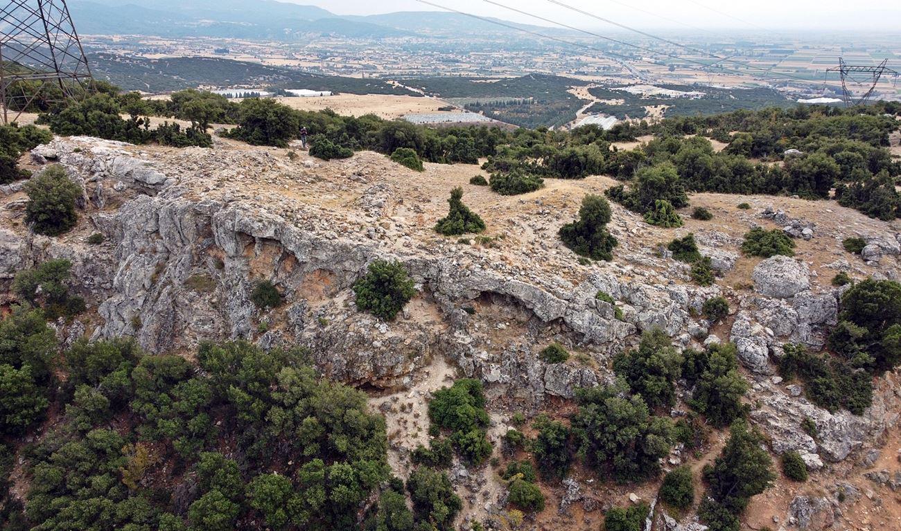
2 / 10

the north wall with the Roupel pass in the background
3 / 10

wall A (length: 6μ, height:1,7μ, thickness:1,5μ)
4 / 10

wall A
5 / 10

wall A
6 / 10

wall B (length 10m, height:1m, thickness:1.5m)
7 / 10

wall B
8 / 10

part of the north wall
9 / 10

the cave west of the castle
10 / 10

the Roupel pass as seen from the castle

THE END
| Location: |
| On a hill at the south entrance of the Roupel pass, 3km NW of the village Thermopigi in Serres prefecture |
| Region > Prefecture: |  |
| Central Macedonia Serres | |
| Municipality > Town: | |
| City of Sintiki • Thermopigi | |
| Altitude: | |
|
Elevation ≈ 250 m (Relative Height≈100 m) |
| Time of Construction | Origin | |
| Unknown | BYZANTINE |
|
| Castle Type | Condition | |
| Castle Ruins |
In Ruins
|
Along the Rupel pass – a passage of strategic importance at the northern end of the prefecture of Serres – two fortified positions of the Byzantine Period have been found. One of them is this castle, the few ruins of which are located on the plateau of a hill named “Zoudan”, 3 kilometers northwest of the village of Thermopigi.
One kilometer west of the hill flows the river Strymon.
Location & Strategic Scope
The Rupel pass is 9-10 kilometers long. Its southern entrance is located between the villages of Thermopigi and Petritsiou and the northern one a little south of the village of Promakhon and the border with Bulgaria. The pass is formed between the mountains of Belles and Agkistro..
In Byzantine times, the strait was one of the most important passageways from the Balkan hinterland to Macedonia and the plain of Serres, connecting two important Byzantine cities: Serres and Meleniko (present-day Melnik, Bulgaria).

Earlier, during Late Antiquity, the Rupel pass was part of a Roman road between two ancient cities that were also Roman stations according to the Peutingerian Table (Tabula Peutingeriana – a medieval copy of an ancient road map network of the Roman Empire). These are the cities of Skotoussa (which was in the Palaiokastro-Siderokastro – not identified) and Heraklia of Sintiki (near the present-day village of Rupite in Bulgaria).
Strabo mentions the straits of Rupel without naming them (Geographic VII, excerpt 36).
We must point out that during the Byzantine era the crossing of the passage did not follow the current riverside route, but from the outskirts of Sidirokastro it approached the fortress of Thermopigi and between the low hills of Agkistron on the eastern side of the Strymon river reached Kleidi (Rupelion/Rupel). From there it continued to Melenikon. The reason for this strange route was that Strymon in those years had much more water and was much wider, leaving little room for crossings parallel to the river. In fact, it is reported that the narrowest point in the passage of Rupel had an opening of just 3 meters!
The fortress of Thermopigi controlled the southern entrance to the Rupel pass and was able to alert the castles of Serres in the event of an enemy invasion. He had visual contact with two important castles of Sintiki: the Siderokastro and the castle Black Rock.
The plateau where the fort is located has natural protection due to the steep slopes of the hill to the north, south and east. From the west it is relatively vulnerable due to the overlying elevation on that side.
The name of the hill “Zudan” probably comes from the Turkish word zindan which means prison, dungeon.
History
The history of the Thermopigi fortress is unknown. Nothing is mentioned in historic sources. In ancient times it belonged to the area of Sintiki.
During the Mid-Byzantine Period, important war events took place in the region. The top historical event was the Battle of Kleidion on June 29, 1014 when Basil II the Bulgar Slayer with his general Nikephoros Xifias achieved a decisive victory against the Bulgarians. The location of Kleidi, where the battle took place, is located on the Strym river but in Bulgarian territory, in the present-day village of Kliuts (=Key/Kleidi) in Bulgaria at the foot of Mount Belles.
Later, in 1255, we have the first historical reference of the strait under the name of Rupeliou dyschoria in the account of another battle that took place inside the straits, again between Byzantines and Bulgarians. (Georgios Akropolites, Chronical Writing, Excerpt 58).
Structure, Fortification & Buildings
In the site, ruins of fortifications are preserved at a small height. Samsaris Petros, who visited the site in 1988, saw the ruins of two towers that were joined by a wall. Today there is no visible trace of these towers. The site seems to have undergone a lot of alteration, and perhaps this happened during the installation of an electricity pylon very close to the ruins of the castle, but also from possible stone removals by shepherds in the area. (Nearby there is a stone-built sheepfold.) Samsaris mentions that at the time he visited the hill a tower had been converted into a storehouse by a local shepherd.
Today there are few wall ruins. Specifically, a wall (“A Wall” in the layout view, photos 2-5) 5-6 meters long, 1.70 meters high and 1.5 meters thick and another parallel wall (“B wall”, photo 6) are preserved ,7) a few meters further west with a length of 10 meters, a thickness of 1.5 and a height of 1 meter.
Both of these walls are perpendicular to a northern wall (photo 8) that is preserved at a low height. Also, next to the 1st wall there is a continuous stone pile of 15 meters which is probably a remnant of a wall.
The construction of the walls consists of mudstone construction with connecting mortar between them and bricks in a disorderly arrangement.
It is worth mentioning that 70-80 meters west of the fortress there is a cave (photo 9) with a vertical opening, like a big crack in the rock, which maybe it is related to the fortress. Outside the cave there is a mass of stones that probably came from the walls of the fortress.
| First entry in Kastrologos: | November 2023 |
Sources
- Research, presentation and photos by Sakis Amfitreidis and his blog ΑΜΦΙΤΡΕΙΔΗΣ (October 2023)
- Σαμσάρης, Πέτρος «Βυζαντινοί τόποι και μνημεία της κάτω κοιλάδας του Στρυμόνα», 2004, Πανεπιστήμιο Ιωαννίνων – Διδακτορική Διατριβή, 2004, σελ. 78β, σχέδιο 93
- Σαμσάρης,Δημήτριος «Ιστορική γεωγραφία της Ανατολικής Μακεδονίας κατά την αρχαιότητα». Μακεδονικά, 16(1), 1976, σελ. 50-51, σχόλιο 4
- Τολούδη Άννα, «ΣΙΝΤΙΚΗ, Ιστορία και παραδόσεις» (Έκδοση εκπολιτιστικού-λαογραφικού συλλόγου Σιδηροκάστρου), Σιδηρόκαστρο 1983. σελ. 15.
|
|
| Access |
|---|
| Approach to the monument: |
| A dirt road that starts east of Thermopigi towards the NE leads after 3 km to a plateau where there is a plastic tank and a pond. There we leave the vehicle and walk 5' to the south, to the plateau with the electricity pylon. |
| Entrance: |
| Free access |


