

Geroplatanos, Igoumenitsa, Thesprotia,Epirus
Castle of Doliani


| Location: |
| On a hill above Kalamas river, between the villages Geroplatanos (Doliani) and Agios Georgios, west of Igoumenitsa, Epirus |
| Region > Prefecture: |  |
| Epirus Thesprotia | |
| Municipality > Town: | |
| City of Igoumenitsa • Geroplatanos | |
| Altitude: | |
|
Elevation ≈ 70 m (Relative Height≈40 m) |
| Time of Construction | Origin | |
| Various periods | ANCIENT |
|
| Castle Type | Condition | |
| Ancient City |
Not Good
|
This was the site of the ancient town Fanoti founded in the late 4th century BC which was inhabited in the following centuries as well, in the Roman, Byzantine and Ottoman periods.
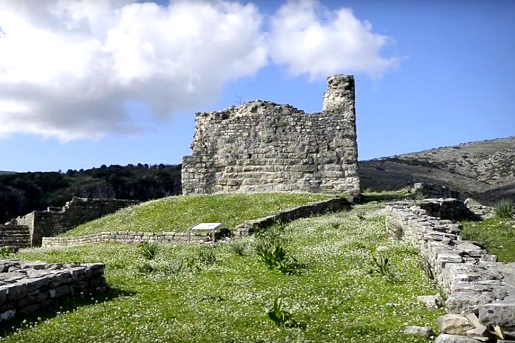
The large square defensive tower at the peak of the hill is dated back to the Roman period. It remained in use for many centuries thereafter.
History
The archaeological site of Doliani, an area of about 55 acres, occupies an isolated limestone hill west of the modern village of Geroplatanos (old name “Doliani”), within the limits of the municipality of Igoumenitsa, Thesprotia. It is a fortified settlement with a double defensive wall, which corresponds to ancient Fanoti, center of the ancient Thesprotian tribe of Fanotians believed to have occupied the area between the Mourgana mountain and midstream Kalamas river.
Reference to Fanoti is made by the Roman historian Livy, who claims the city effectively repelled the siege of the Roman troops in 170/169 BC, only to surrendered to the Roman general L. Anicius the following year, first of all the cities of Epirus.
The fortified settlement was established in the second half of the 4th century BC and flourished during the Hellenistic period. After the Roman conquest, the settlement suffered extensive damage and the town for the most part was deserted but not abandoned.
The occupation continued for a long time within the citadel (Roman, Byzantine and Ottoman period). In the middle Byzantine period a Christian church was constructed on the western tower of the outer enclosure gate. Besides the church, a settlement should have existed in the region, as suggested by the existence of a large cemetery, parts of which are located around the Christian church and the slopes of the opposite hill, in the same location as the cemetery of the ancient city.
During the Byzantine period the inner fortification wall was thoroughly repaired and a square tower was built at the highest point of the citadel. The inhabitance of the citadel is again ascertained during the Ottoman period and continues until more recent years, when the settlement was finally abandoned.
| First entry in Kastrologos: | February 2016 |
Sources
- Website ΟΔΥΣΣΕΥΣ - Greek Ministry of Culture Doliani, author: Vasiliki Lamprou, archaeologist
- Article in Wikipedia Αρχαία Φανοτή based on the work «Χαράλαμπος Γκούβας: Μελέτη, και φωτογράφηση της Αρχαίας Φανοτής, 2012,»
- Presented in cooperation with Mr. Ioannis Dedes
|
|
| Access |
|---|
| Approach to the monument: |
| The is an upcountry road leading to the site from the NR Igoumenitsa-Ioannina (distance 3km). The total distance from Igoumenitsa is 16km |
| Entrance: |
| The site is not accessible due to works by the Archaeological Service (2012) |


