

Lygourio, Epidavros, Argolis,Peloponnese
Palygourio
or Castle of Palaio Lygourio
1
2 / 11

north wall - S.Lemonakis - Sep 2019
3 / 11

north wall - S.Lemonakis - Sep 2019
4 / 11

north wall - S.Lemonakis - Sep 2019
5 / 11

north wall - S.Lemonakis - Sep 2019
6 / 11

south wall detail - S.Lemonakis - Sep 2019
7 / 11

south side - S.Lemonakis - Sep 2019
8 / 11

ruins of buildings - S.Lemonakis - Sep 2019
9 / 11

ruins of buildings - S.Lemonakis - Sep 2019
10 / 11

tower/cistern - S.Lemonakis - Sep 2019
11 / 11

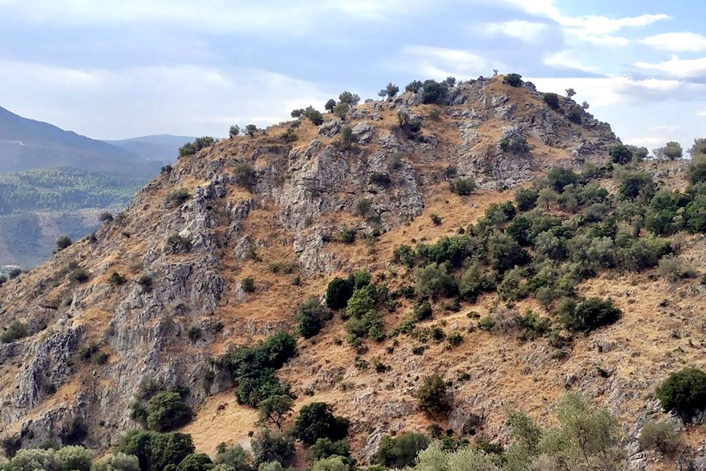
the hill with Arachnaion in the background

THE END
| Location: |
| On a rocky hill of mount Arachnaion, 4.5km NE of Lygourio in Argolis, northeastern Peloponnese |
| Region > Prefecture: |  |
| Peloponnese Argolis | |
| Municipality > Town: | |
| City of Epidavros • Lygourio | |
| Altitude: | |
|
Elevation ≈ 460 m (Relative Height≈100 m) |
| Time of Construction | Origin | |
| Unknown | BYZANTINE |
|
| Castle Type | Condition | |
| Castle |
In Ruins
|
Remains of fortifications and buildings on a steep hill at the eastern side of the mountain range of Arachnaion in Argolis. This was most probably the location of the medieval settlement Ligorio, i.e. the Old Lygourio.
History
The town of Lygourio (or Ligourio) is in Argolis, south of mount Arachnaion between Nafplion and Epidaurus. It is built at the location of the ancient polis Lissa (mentioned by Pausanias) which was on the route to Epidaurus and the famous temple of Asclepius. In the area there are many remains from different periods starting from the Mycenaean era.
During the Byzantine period, the place was populated and developed judging from the numerous old churches in the region, including the ruins of 7 early-Byzantine churches.
During the Middle Ages the center of the area was not at the spot of modern Lygourio but on this hill 4.5km to the northeast.
This old Lygourio or “Palygourio” must have been here since the dawn of the Byzantine period but it is not mentioned by any historical source before the 14th century. In the list of fiefs of 1377 Ligorio is recorded as one of the fiefs belonging to the Kastellania (county) of Corinth and it was one of the castles that were granted to Nicolo Acciaiuoli, in the middle of 14th century, as a reward for his services to the Principality of Achaea. The region and Paliygourio remained in the hands of the Acciaiuoli family for one century.
Although Palygourio was in Acciaiuoli's domain, the owner was a Catalan named Arnas Caopena who in 1451 became the rettore of the territory (including Aegina island), when these lands were ceded by the Duke Antonio Acciaiuoli to the Venetians. The name Arnas still survives in the area: it is the name of the plateau north of the mountain and west of the castle of Palygourio.
Palygourio appears in the lists of the fiefs of the 15th century (1463 and 1471) with a different name: Arnavilla. This hypothesis has never been proposed before but we think it is likely to be true, for the following reasons:
1) Ligorio remained an important town and there was no reason to disappear from the lists of the castles of the 15th century, unless it is was recorded under a different name.
2) Arnavilla is related to Arnas both as the name of the region and also as the name of the landowner (not to mention the name of the Venetian governor). An attempt to have a town in his place with his name is reasonable and he had the power to impose it (although it did not survive as it was not adopted by the locals, apparently)
3) The suffix villa is unusual for fief names in the Moreas. It was used only one more time: In the Venetian census of 1704, for Lygourio (Villa Ligoriò —it can’t be a coincidense )
4) The modern village Arna in Laconia which is commonly identified with the medieval Arnavilla is completely absent otherwise from the Frankish history of Peloponnese. The ruins of one “Paleokastro” nearby are of unknown origin, possibly Hellenistic. The chances that this remote and obscure village to have been Arnavilla are slim.
In any case, Lygourio is mentioned many times in the following centuries with variations of the “Lygourio” version (which, by the way, is of unknown origin and etymology). Palygourio remained under Venetian control until 1463 when it was occupied by the Ottomans. The Venetians came back for a short period between 1685-1715. It is interesting that in the census of 1704 we have the placename Villa Ligoriò for the place where is the modern village and the placename Paleò Ligoriò at the location of the castle without any indication of settlement. That means that the modern village was founded earlier and that by that time Palygourio was already abandoned. This change –the desertion of the Palaio Lygourio– must have happened around the 16th century.
Structure, Fortification & Buildings
The castle is almost totally in ruins. The highest point is its western side where are the remains of a tower / cistern. The perimeter of the fortification is about 500m. There are wall ruins, 1m high on average, along the entire perimeter, even in the parts where the rock is steep.
At the northern side, a part of the wall reaches 4m which is the maximum preserved height. At the eastern side we see the foundations of two structures which were probably towers protecting a gate.
Mortar has been used in the construction of all walls together with tiles fragments. This technique is a clear indication of a medieval –and probably byzantine– structure.
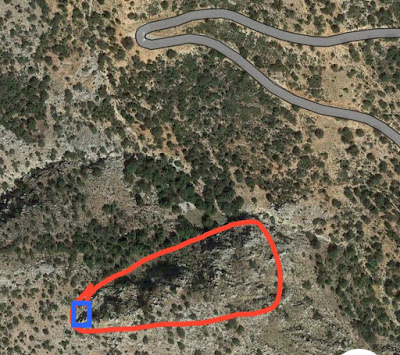
red: the castle outline, blue: the tower/cistern
| First entry in Kastrologos: | October 2019 |
Sources
- Photographs and info by Sakis Lemonakis and his blog ΑΜΦΙΤΡΕΙΔΗΣ
- Website ecastles - Παλαιό Λυγουριό
- Website of the municipality of Epidavros - Λυγουριό
- b>William Miller, “The Latins In The Levant: A History Of Frankish Greece, 1204-1566”, New York, 1908
- Antoine Bon, 1969, La Morée franque. Recherches historiques, topographiques et archéologiques sur la principauté d'Achaïe (1205-1430), Editions de Boccard, pp.479, 484-485
- Website ΑΡΓΟΛΙΚΗ ΑΡΧΕΙΑΚΗ ΒΙΒΛΙΟΘΗΚΗ ΙΣΤΟΡΙΑΣ ΚΑΙ ΠΟΛΙΤΙΣΜΟΥ - Αραχναίο (Χέλι) Αργολίδας
|
|
| Access |
|---|
| Approach to the monument: |
| From Lygourio to Koutsaveika by car . After that village we see the hill on the left. We park and take a 30min walk to the hill. Access from the western/highest side. Dangerous path, caution is needed. |
| Entrance: |
| Free access |


