

Ano Souli, Marathon, Eastern Attica,Attica
Fortifications of Agios Dimitrios
1
2 / 9

photo Yohannes Dedes, Aug 2021
3 / 9

photo Yohannes Dedes, Aug 2021
4 / 9

photo Yohannes Dedes, Aug 2021
5 / 9

photo Yohannes Dedes, Aug 2021
6 / 9

photo Yohannes Dedes, Aug 2021
7 / 9

photo Yohannes Dedes, Aug 2021
8 / 9

photo Yohannes Dedes, Aug 2021
9 / 9

photo Yohannes Dedes, Aug 2021

THE END
| Location: |
| In the hilly location Agios Dimitrios 1.3km south of the village Ano Souli of Marathon in Attica |
| Region > Prefecture: |  |
| Attica Eastern Attica | |
| Municipality > Town: | |
| City of Marathon • Ano Souli | |
| Altitude: | |
|
Elevation ≈ 350 m (Relative Height≈170 m) |
| Time of Construction | Origin | |
| Unknown | Unknown |
|
| Castle Type | Condition | |
| Castle Ruins |
In Ruins
|
Fortress complex consisting of two fortifications that are independent of each other, but close to each other and with similar construction, in the semi-mountainous location of Agios Dimitrios 1.3 km south of the village Ano Souli in the municipality of Marathon, Attica.
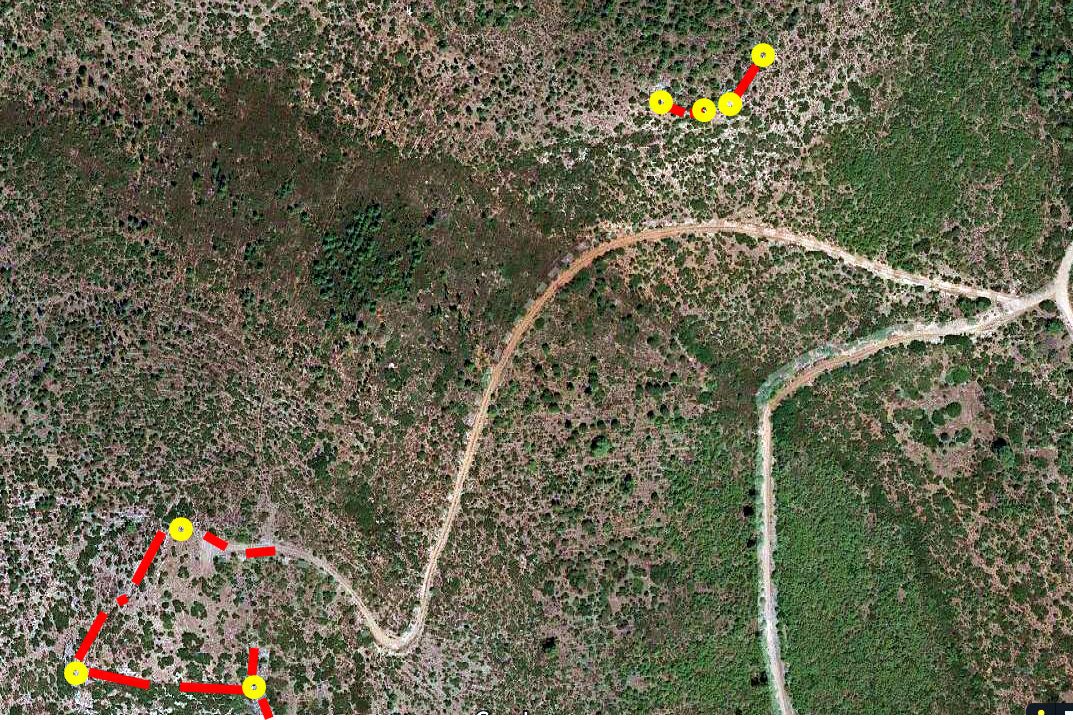
the position of the two fortifications in Agios Dimitrios(the towers in yellow)
History
The history of the fortifications in Agios Dimitrios is unknown. They are not mentioned in any sources and the date of their construction is not known.
The type of stone construction does not help as it could belong to a very wide time range, from the Middle Byzantine period to the Tourkokratia.
Our hypothesis (not supported by on-site evidence) is that the fortification is from the Byzantine period –perhaps the 7th or 8th century– when the population of Greece had to withdraw from the plains and the coasts and seek refuge in the mountains because of the raids of Slavs and Saracens.
Structure, Fortification & Buildings
As mentioned, there are two fortifications and not one, but they are presented together here because they are very close - at a distance of 300m from each other. Moreover, it is obvious that they are from the same era and by the same manufacturer.
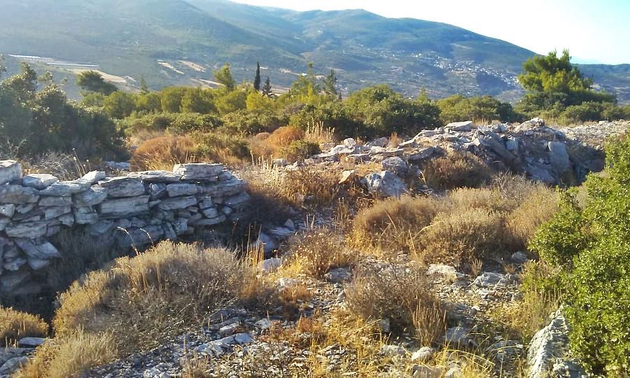
The southern fortification, which is the largest, at an altitude of 350 meters, is trapezoidal in shape and covers an area of more than 4000 sq.meters.
The fortified enclosure is preserved at a low height on 3 of its 4 sides, the west, the south and the east.
At the corners there are three cylindrical towers: with a diameter of 4.80 meters the southwest, 6.30 meters the northwest and 6.50 meters the southeast.
The thickness of the walls is 0.9 to 1m along their entire length. The walls as well as the towers are made of local slate stone, without any use of mortar. The stonework, however, is elaborate, with very good joints.
No traces of ramparts or merlons or loopholes have been observed. Internally, a trench has been dug along the entire length of the walls for the movement of the defenders. It is possible that this perimeter was opened later because it is lower than the preserved height of the wall (that is, it may have been excavated when the fortification was already destroyed). The same applies to the 3 towers, where the level of their floor is deeper than the external level.
The second fortification is located on the opposite hill to the north which has a slightly lower height (around 325) and was smaller. Only the south-southeast side of the fortification and 4 round towers that are very close to each other are visible here. The style of construction is the same as the first fortification, on the south hill.
The whole construction is quite unusual and does not look like any other of the fortifications in Kastrologos.
No ruins of buildings can be seen inside the fortifications. However, there are several ruins of buildings in the area - outside from the fortifications.
| First entry in Kastrologos: | September 2021 |
Sources
- Research, presentation and photos (Aug 2021) by Yohannes Dedes
- Νίκος Νέζης, “ΤΟΠΩΝΥΜΙΚΑ ΤΗΣ ΑΤΤΙΚΗΣ, ΟΙΚΙΣΜΟΙ-ΜΝΗΜΕΙΑ-ΤΟΠΩΝΥΜΙΑ” , εκδόσεις Ανάβαση, Αθήνα 2013
|
|
| Access |
|---|
| Entrance: |
| Free access |


