

Heliokomi, Amfipoli, Serres,Central Macedonia
Castle of Heliokomi
1
2 / 18

southeastern wall
3 / 18

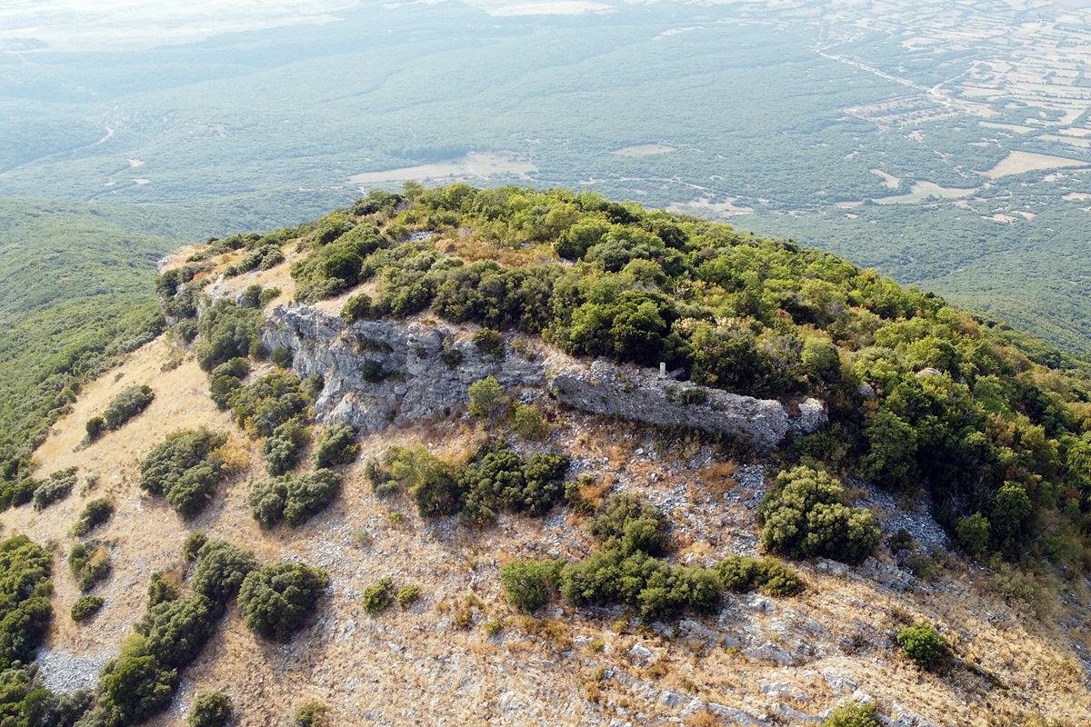
southeastern wall
4 / 18

the steep rocks of the southern side
5 / 18

northeastern wall (l=25m, h=2-2.5m)
6 / 18

northeastern wall (l=25m, h=2-2.5m)
7 / 18

parts of the NE wall
8 / 18

traces of wall at the northern side
9 / 18

a wall from the inside
10 / 18

fortification of the east side with an opening (gate?)
11 / 18

stone piles fron unknown buildings in the interior
12 / 18

capital of a column (d=30cm) from the interior
13 / 18

fragments οφ πιτηαριθμ μοθτησ φρομ τηε ιντεριορ
14 / 18

semi-circular ruin from a church
15 / 18

the entrance to the church
16 / 18

view to the neck, at the east, that leads to the castle
17 / 18

view of the interior; the stone piles from ruined buildings are visible
18 / 18

the hill of the castle from the east

THE END
| Location: |
| On a mountain 3km southeast of the village Heliokomi in Serres perfecture |
| Region > Prefecture: |  |
| Central Macedonia Serres | |
| Municipality > Town: | |
| City of Amfipoli • Heliokomi | |
| Altitude: | |
|
Elevation ≈ 925 m (Relative Height≈570 m) |
| Time of Construction | Origin | |
| Unknown | BYZANTINE |
|
| Castle Type | Condition | |
| Castle |
In Ruins
|
Ruins of a Byzantine castle on a hill with a relatively high altitude (925m), with the name “Kailes”, 3 kilometers southeast of the village of Heliokomi in the prefecture of Serres, in North Greece.
History
The history of the castle is unknown. It has not been identified with any fortification or settlement from the historical sources.
Chronologically it is placed -broadly- in the Byzantine period. Perhaps it already existed from the late Roman period.
According to one hypothesis, the castle was a monastery: the fortified monastery of Agii Anargyri. This hypothesis is based on an 11th-century chrysobulus of the emperor Alexios Komnenos (1081-1118), in which such a (fortified) monastery is mentioned above the village Koromista (modern Kormista).
Iliokomi, which is the closest village to the castle, is mentioned as “Tserepliani” in January 1316 in a census record of the orphanotrophos Tryfon Kedrinos, in which the presence of 22 households is recorded. In an Ottoman tax register of 1454/5 it is mentioned as Ĉereplen with about 711 Christian inhabitants and 5 Muslims. In 1934 it was renamed Heliokomi.
At the same time, the neighboring Kormista existed, which is mentioned in the late Byzantine period as a village and survives as a village to this day. Related references in the period 1265-1361 with names: Koromista, Koremistou, Koremista, Goremista and Koremitza.
In the interior of the castle, ceramics from Byzantine and Roman times were found. Perhaps there was an earlier settlement at the site related to the exploitation of the gold-bearing deposits of Mount Pangaion. (In the wider area around the castle there are traces of ancient mining activities.)
Structure, Fortification & Buildings
The castle has an elongated shape on the east-west axis. The eastern end is the highest point of the castle (925m) and the western end is the lowest (890m). The perimeter of the castle is about 450 meters.
On the south long side there is no fortification, because the vertical rocks on this side provided natural protection (photo 4).
At the west and to the north sides, which are quite sloping, there are few traces of a wall which seem to have been covered by the dense vegetation.
South and northwest of the castle there are deep ravines.
The remains of a wall 80 meters long that cover the vulnerable narrow eastern part are preserved from the fortification. Actually, the eastern side is a triangular pinpoint from which a wall starts in a SE and NE direction. It is a wall with a height ranging from 2 to 3.5 meters and a thickness of 1.5 to 2.5 meters. Its construction consists of stones with connecting mortar between them.
On the western and northern long sides which are on sloping ground, few traces of a wall were found. Unclear if it was surrounded by a continuous wall as on the east side.
Next to the SE wall were found the ruins of a Byzantine church. More specifically, the ruins of the semicircular niche of the sacred step (photo 14) and another building adjacent to the SE wall were found. This part (south of the sacred step) was probably the place called diakonikon in ecclesiastical terms. The upper part of the door that led to the diakonikon is preserved (photo 15). Scattered architectural elements were observed within the ruins of the temple, but also around it, such as relief marbles, parts of columns and capitals (photo 12).
The ruins of this Byzantine church have been uncovered after an excavation by treasure hunters in 1970.
Within the perimeter there was a dense construction of houses and other buildings. The interior today is scattered with piles of stones, building foundations and broken roof tiles (photos 11,17). Also among the scattered ceramics, many fragments of mouths of jars were observed (photo 13).
| First entry in Kastrologos: | October 2023 |
Sources
- Research, presentation and photos by Sakis Amfitreidis and his blog ΑΜΦΙΤΡΕΙΔΗΣ (September 2023)
- Σαμσάρης, Πέτρος «Βυζαντινοί τόποι και μνημεία της κάτω κοιλάδας του Στρυμόνα», 2004, Πανεπιστήμιο Ιωαννίνων – Διδακτορική Διατριβή, 2004, σελ. 340-342 και 615
- Facebook page, Theodoros Dimosthenis Lymperakis, ΚΑΣΤΡΑ ΤΟΥ ΠΑΓΓΑΙΟΥ ΟΡΟΥΣ - ΤΟ ΒΥΖΑΝΤΙΝΟ ΚΑΣΤΡΟ ΤΗΣ ΗΛΙΟΚΩΜΗΣ (Δεκέμβριος 2019)
|
|
| Access |
|---|
| Approach to the monument: |
| Approach on foot from a dirt road (not passable by vehicle) that starts south of the village. A strenuous 4 km hike is required. This road ends right in front of the castle. |
| Entrance: |
| Free access |


