

Proti, Amfipoli, Serres,Central Macedonia
Castle of Proti
1
2 / 16

part of the north wall
3 / 16

northeast corner of the wall
4 / 16

part of the north wall
5 / 16

part of the north wall
6 / 16

wall at the eastern neck of the hill
7 / 16

northwestern tower
8 / 16

part of the northwestern tower
9 / 16

remains of wall at the west side
10 / 16

the rocks protecting the southern side of the hill
11 / 16

stone piles inside the perimeter
12 / 16

ruins of the foundation of a building inside the castle
13 / 16

the position of the settlement outside the castle
14 / 16

the wall with the scaffold holes
15 / 16

the monastery of Analepsis opposite the castle
16 / 16

the hill of the castle from north (the wall is visible), left the monastery

THE END
| Location: |
| On a mountain 4km east of the village Proti in Serres prefecture, Central Macedonia |
| Region > Prefecture: |  |
| Central Macedonia Serres | |
| Municipality > Town: | |
| City of Amfipoli • Proti | |
| Altitude: | |
|
Elevation ≈ 915 m (Relative Height≈100 m) |
| Time of Construction | Origin | |
| around 4th cent. | Early ΒΥΖΑΝΤΙΝΕ |
|
| Castle Type | Condition | |
| Castle Ruins |
In Ruins
|
Ruins of a castle on a peak of Mount Pangaion, in a place called "Kailias", 4 km east of the village of Proti in the prefecture of Serres.
This is a castle probably from the Byzantine period in a difficult location and at a high altitude (915m).
An alternative name for the castle – apparently a remnant of the Turkish occupation – is “Seitan Kale” (=Devil’s Castle).
History
The castle has not been identified with any mentioned in the historical sources and its history is not known. The lack of references to such a stronghold with a large settlement means that it probably did not survive into the Middle Byzantine Period. From the use of mortar present in masonry, it is dated from the 3rd-4th century AD the earliest.
Its existence is probably related to the exploitation of the gold mines on Mount Pangaion. Indeed, at the site of Gournes, located 400 meters north of the Ascension Monastery, it is said that there are the ancient gold mines of the mountain. Therefore, chronologically we will tentatively place it in the Early Byzantine Period.
Opposite the castle of Proti, on a similar high altitude of Mount Pangaion and 1 km to the northeast, is the castle Heliokomi. Also, nearby and in a similar position at a high altitude is the castle Rodolivos, which probably dates from the same period .
As a general observation, we have to say that fortified settlements at such high altitude (as in the case of the castles of Proti, Heliokomi, Rodolivos) are not common. Usually such settlements served as refuges in times of danger. This remark does not help much with the dating of these fortifications, but is compatible with a possible dating in the 4th century as this is when the raids of barbarian tribes (Huns, Goths, etc.) began that devastated the lowlands of Thrace and Macedonia.

The location of the castle in relation to the castle of Heliokomi
Structure, Fortification & Buildings
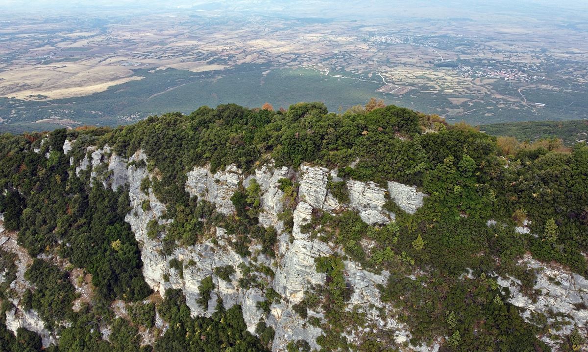
The castle extends along a long, narrow ridge of Mount Pangaion, running from east to west. It is separated from the east by a rocky neck. From the south it has vertical rocks and from the north and west it has steep and sloping slopes.
From the castle today remains of the perimeter fortification with a wall that is kept at a relatively high height, which in some places reaches up to 4 meters.
The perimeter follows the rough relief of the ground and is about 270 meters.
The construction of the wall consists of stone construction with connecting mortar and few ceramics. From the south-east and east side where the neck is located to the north-west corner there is a continuous wall 130 meters long with a height varying from 2 to 4 meters. The best-preserved parts are on the elongated northern side (photos 2, 4, 5, 16).
The northern wall ends at the NW corner where there are ruins of a tower (photos 7,8), which probably had a semicircular shape. From this tower begins the western side (photo 8), of whose wall only a few traces are visible (which is strange because on the SE, N and E sides the wall is preserved to a considerable height and length).
The steep south side (photo 10) had no fortification since the vertical rocks ensured natural protection and made it inaccessible.
There was a settlement within the walls. In the dense vegetation, there are building foundations, piles of stones, scattered ceramics that are remains of the buildings inside the castle. At the top of the castle (915m) there are the foundations of a two-space rectangular building and in the eastern corner the ruins of a circular building that has collapsed.
Along the western slope and outside the wall, there is an area of destroyed buildings, a dense presence of ceramics, fragments of jars and foundations of buildings. It seems that the settlement extended outside the castle, along the western slope for about two hundred meters (photo 13). In this external area, close to and outside the NW corner of the castle, there is a wall 4 meters long and 1.5 m high (photo 14) in which there are 8 circular holes of approximately 30 cm, possibly sockets for wooden beams.
Opposite the castle, is the women's Monastery of the Ascension (photo 16) which was founded in 1979 on the site of an older chapel of the same name, which was dependency of the Monastery of Panagia Eikosifinisa. Also, in the location “Askitario” located somewhere on the southern steep slope of the castle, the existence of an old hermitage is mentioned, which was not found during the on-site investigation (2023).
| First entry in Kastrologos: | November 2023 |
Sources
- Research, presentation and photos by Sakis Amfitreidis and his blog ΑΜΦΙΤΡΕΙΔΗΣ (October 2023)
- Σαμσάρης, Πέτρος «Βυζαντινοί τόποι και μνημεία της κάτω κοιλάδας του Στρυμόνα», 2004, Πανεπιστήμιο Ιωαννίνων – Διδακτορική Διατριβή, 2004, σελ. 704-705
|
|
| Access |
|---|
| Approach to the monument: |
| Asphalt road 6.5 km from Proti leads to Ascension Monastery. 150m before the Monastery, a dirt road of 5.5 km leads to “Potistra” (traugh). From there we reach the castle with a difficult hike of 800m to the west. |
| Entrance: |
| Free access |


