

Atávyros, Rhodes, Dodecanese,South Aegean
Fortified monastery on Mt. Atávyros


| Location: |
| About 100m from the peak of Mt. Atávyros in Rhodes |
| Region > Prefecture: |  |
| South Aegean Dodecanese | |
| Municipality > Town: | |
| City of Rhodes • Atávyros | |
| Altitude: | |
| Elevation ≈ 1200 m |
| Time of Construction | Origin | |
| 5th/6th cent. | BYZANTINE |
|
| Castle Type | Condition | |
| Castle-Monastery |
In Ruins
|
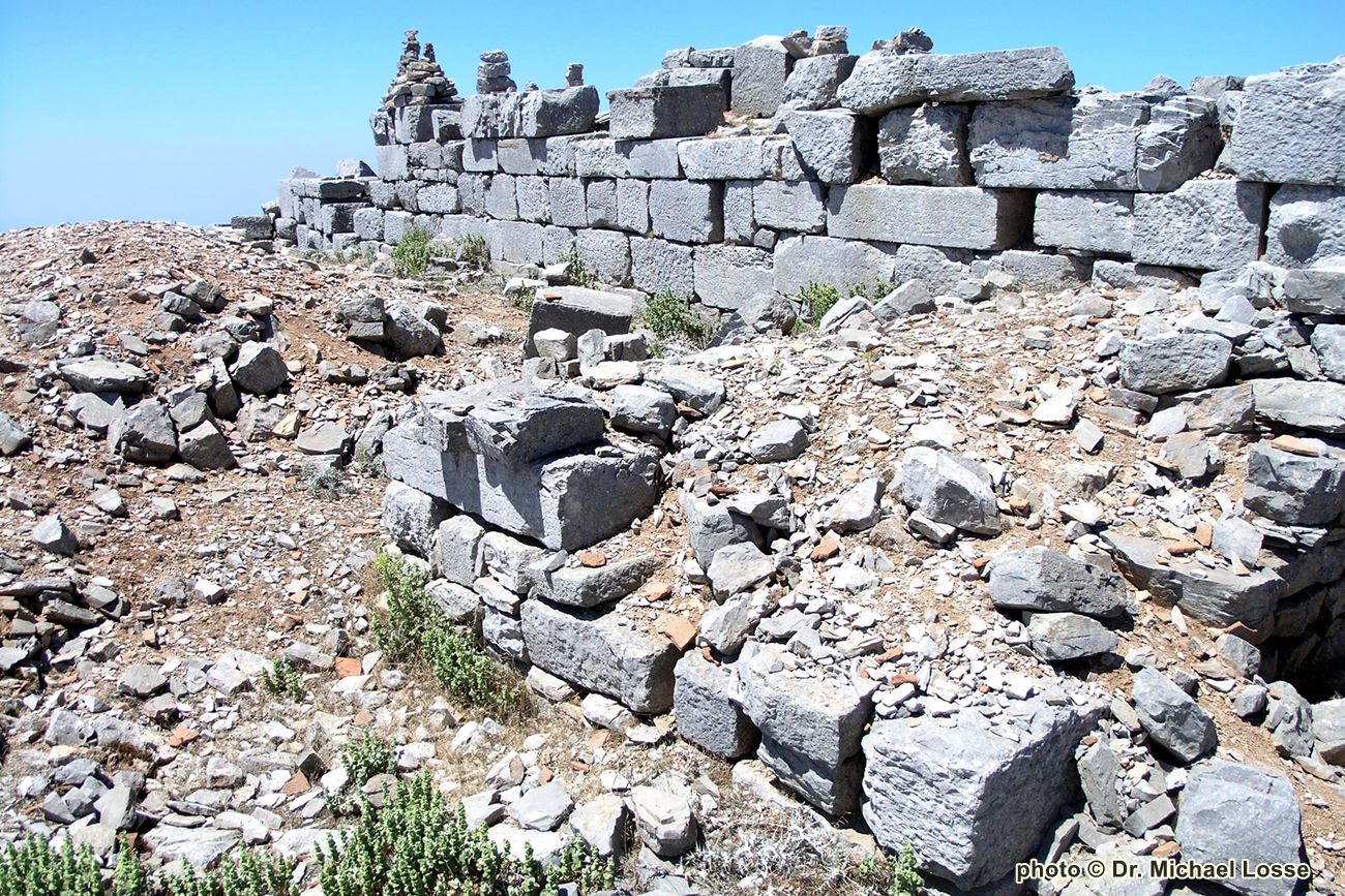
Ruins of a Byzantine fortified monastery above the ruins of the temple of Zeus near the peak of mount Atavyros in Rhodes island.
Castle Description
Text: Dr. Michael Losse – Singen (Hohentwiel), Germany (27.09.2021)General Description
Mt. Atavyros (1216 m) is the highest mountain on the island of Rhodes. About 100 m from its summit, which is now occupied by a radar station and accessed by a road, the foundations of a temple of Zeus can be found.
The archeologist Dr. Paul Triantafyllidis (2013) reported: “The Pan-Rhodian sanctuary of Zeus Atavirios is located […] on the high mountain Ataviros, at the borderline of the ancient Kameiros territory. It is one of the most important sanctuaries of Rhodes, which had a universal reputation to the then known edges oft he ancient Greek world. […] The sanctuary was excavated for a short time in 1927 by the then Italian Archeological Service, when the Dodecanese was under the Italian occupation. […] significant architectural remains were uncovered dated probably to the 5th and 4th century BC; these are the sacred peribolos with the altar, on which an early Christian basilica and a Byzantine chapel were built at a later phase […].“
Because of the strong changes in the summit area, a description from the 19th century should be sent ahead. The archaeologist Prof. Ludwig Ross (1845) wrote:
“The Peribolos of Zeus lies on a round peak, only about a hundred steps southeast below the highest peak of the mountain, [...]. The pile of rubble still rises three to four feet above the ground; the material is blue marble blocks from the mountains themselves, the largest up to five feet long. Later times alone seem to have rummaged everything up in order to turn it into a fortified monastery, whose existence, in addition to tradition, also bears witness to the existence of many shards of bricks, and now even the small capelle of St. John, which stands in the middle of the rubble, is without a roof. I found no trace of columns, and saw only a single architrave with a simple profiling” (Ross III 1845, pp. 106-107).
German original text: „Der Peribolos des Zeus liegt auf einem runden Gipfel, nur etwa hundert Schritte südostwärts unterhalb der höchsten Spitze des Berges, […]. Der Trümmerhaufen erhebt sich noch drei bis vier Fuß über den Boden; das Material sind blaue Marmorquadern vom Gebirge selbst, die größten bis zu fünf Fuß lang. Allein spätere Zeiten scheinen Alles umgewühlt zu haben, um ein befestigtes Kloster daraus zu machen, von dessen Existenz, außer der Ueberlieferung, auch das Vorhandenseyn von vielen Ziegelscherben zeugt, und jetzt ist selbst die kleine Capelle des h. Johannes, die in der Mitte der Trümmer steht, ohne Dach. Von Säulen fand ich keine Spur, und sah nur einen einzigen Architrav mit einer einfachen Profilirung.“)
In and next to the temple are cisterns.
The fortified Byzantine monastery consisting of a rectangular enceinte, had two rectangular “towers” in the east and a “double tower” gate with rectangular towers (or rather with flanking defensive works) on the north side. Since the flanking buildings are not preserved in full height, it remains unclear whether they were real towers.
During the 2nd World War, the monastery was apparently re-fortified (by Italians?) ?), as I was told by shepherds. Trenches and a wall around the ruin bear witness to this.
Access
From Embona and Agios Isidoros, footpaths lead to the mountain. An approximately 10 km long road leads to the mountain, branching off between Siana and Agios Isidoros.
History of the castle
Unknown, but built during the Byzantine period, most probably in the "Dark Centuries". During the 2nd World War, the monastery was re-fortified (by Italians?) with trenches and a wall around the ruin.
Around the former monastery there are larger quantities of ceramics (partly 5th/6th century). Inexperienced, stupid visitors damaged parts of the complex by stacking up so-called "stone pyramids", for which they took stones from the ruins.
Other Info
SourcesBerg, Albert: Die Insel Rhodus, aus eigener Anschauung und nach den vorhandenen Quellen historisch, geographisch, archäologisch, malerisch beschrieben und durch Originalradirungen und Holzschnitte nach eigenen Naturstudien und Zeichnungen illustrirt von Albert Berg. Braunschweig 1862, p. 164.
Losse, Michael: Die Burgen und Festungen des Johanniter-Ritterordens auf Rhódos und in der Ägäis (Griechenland) 1307-1522. (Publisher: Nünnerich-Asmus Verlag) Mainz 2017.
Losse, Michael: Burg und Expansion in der Südost-Ägäis: Von den byzantinischen Befestigungen der „Dunklen Jahrhunderte“ (8.-10. Jahrhundert) bis zur Invasion der „Franken“ (13./14. Jahrhundert) und Osmanen (15./16. Jahrhundert). In: Europäisches Burgeninstitut (Ed.): Burg und Expansion (will be released in 2021).
Losse, Michael: Klosterburgen und befestigte Klöster auf den Dodekanes (Griechenland) – ein Überblick. In: Anja Grebe/G. Ulrich Großmann/Thomas Kühtreiber (Eds.): Klosterbefestigungen – Klöster, Stifte und Wehrbau (series: Forschungen zu Burgen und Schlössern). Petersberg 2021 (will be released later in 2021/22).
Ross, Ludwig Reisen auf den griechischen Inseln des ägäischen Meeres. Dritter Band. Enthaltend Melos, Kimolos, Thera, Kasos, Karpathos, Rhodos, Chalke, Syme, Kos, Kalymnos, Ios (Reisen und Länderbeschreibungen in der älteren und neuesten Zeit, eine Sammlung der interessantesten Werke über Länder- und Staaten-Kunde, Geographie und Statistik 31). Stuttgart, Tübingen 1845, pp. 106-107.
Triantafyllidis, Paul: Topographic mapping and planning of the Pan-Rhodian sanctuary of Zeus Atavirios. In: Magdalene Alvanou (Ed.): Island Identities. The Contribution of the Secretariat General for the Agean & Island Policy to the Research and Promotion of the Culture of the Aegean Archipelago. Mytilene 2013, pp. 61-62.
| First entry in Kastrologos: | October 2021 | Last update of info and text: | July 2022 | Last addition of photo/video: | July 2022 |
Sources
- Αrticle by Dr. Michael Losse (and photo1, 2007)
- Photo 2 by Dr. Mathias Piana. 2007
|
|
| Access |
|---|
| Approach to the monument: |
| From Embona and Agios Isidoros, footpaths lead to the mountain. An approximately 10 km long road leads to the mountain, branching off between Siana and Agios Isidoros. |
| Entrance: |
| Free access |