

Arnitha, Rhodes, Dodecanese,South Aegean
Erimokastro


| Location: |
| On the mountain Erimokastro or Palaiokastro at an air-distance 2200m east of the village Arnitha of southern Rhodes |
| Region > Prefecture: |  |
| South Aegean Dodecanese | |
| Municipality > Town: | |
| City of Rhodes • Arnitha | |
| Altitude: | |
|
Elevation ≈ 440 m (Relative Height≈350 m) |
| Time of Construction | Origin | |
| Mid-Byzantine | BYZANTINE |
|
| Castle Type | Condition | |
| Castle Ruins |
In Ruins
|
Fortified Byzantine Kástron and settlement of the "Dark Centuries" on a steep mountain.
Castle Description
Text: Dr. Michael Losse, Singen (Hohentwiel), Germany (27.06.2021)
General Description
Arnítha is located in the south of Rhódos, east-southeast of Apolakkiá. The mountain with the ruins of the Erimókastro rises 2.2km (air-distance) east of the village. Erimókastro at Arnítha is one of three fortifications on Rhodes that bear this name in the vernacular.
Giuseppe Gerola (1914) gives a reference to the medieval “Erimòkastro” near Arnítha, but he may not have visited the fortification he called “Fortilizio” himself (p. 335: “Ruderi medioevali pare si trovino alla località *Erimòkastro”), as it is a vast fortification. Occasionally on maps of Rhodes and in older literature the name “Palaiókastro” for the Erimókastro can be found (for example Ernst Kirsten/Wilhelm Kraiker: Griechenlandkunde. Ein Führer zu klassischen Stätten. 1957, 3rd edition. Heidelberg [Germany] 1967, p. 363).
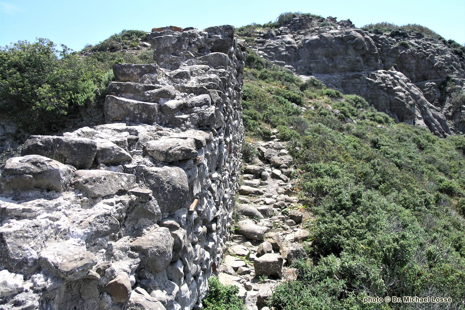
The over 400 m high mountain Erimókastro (meaning “castle in solitude” or “abandoned castle”) is a steep, elongated, widely visible stepped ridge. Around the summit area runs the irregularly enceinte of a fortified Byzantine settlement (most probably of the Dark Centuries) following the edges of the ridge.
Although in the interior of the densely overgrown enceinte not many building remains are recognizable, but there is a lot of collapsed masonry on the middle hilltop. Indications of intensive settlement or use of the interior areas are large quantities of ceramics and brick splitting. Occasionally there are sherds with mortar remains, which maybe indicate brick tweaking in the masonry.
The disappearance of the interior buildings, with the exception of the cisterns, probably goes back to stone robbery, because the region offers little suitable building material. In the past centuries, the mountain was used for agriculture (arable terraces).
The up to 1.2 m thick enceinte without flanking works or towers, which is preserved at various points about 2 m high, consists of quarry stone, partly in (later?) mortar setting. Individual (antique?) ashlars can be seen in the outer shell of the wall. Where the ashlars sitting in several field terraces come from and whether they were formerly installed in the enceinte, can not be clarified. Michael Heslop (2009, p. 72) assumed an ancient predecessor building.
Heslop’s description: “built or remodelled on Hellenistic foundations. Erimokastro, at a height of over 500 metres, dominates the whole of the surrounding countryside and encloses a substancial area. The site consists of three inter-connecting peaks, approached with great difficulty from the south-west: there are no apparent remains of a path or track. The first peak is surrounded on three sides by roughly-hewn walls […]. Remains of walls also surround much of the other two peaks, while the whole area is covered by the confused remains of walls, buildings and staircases, as well as two cisterns. […] The size of the enclosed area shows that this location was a key retreat for many villagers and their livestock from large areas of the south of the island.”
The up to 2.5 m high ruined building (12✖7 m) in the north saddle with 0.75 up to 1.00 m thick walls, pillar approaches inside and wall bench or base on the outside was described by locals as church ruins. Heslop called it a Byzantine residential tower. Its mortar masonry consists of ashlars and brick developments.
The mountain of Erimókastro provides views to some other medieval fortifications and vígles on Rhodes, among others to Mt. Atávyros, Siána Castle, Meróugli (local dialect for Merovígli), the castles of Asklipió and Apolakiá and to the fortification on Mt. Vouni next to Mesanagrós. There are view connections to Vígles on the east coast. Also the islands of Sariá, Kárpathos and Chálki can be seen from here.
Access
By car to Arnítha. The Kástro can be reached by a 40 minutes walk from Arnítha on sight via a dirt road that branches off after a few hundred meters to the left through a wide dry valley from the unpaved road Arnítha-Mesanagrós, in the upper part bad road, which leads up on the southwest side of the Erimókastro mountain. At its southern tip, goat paths lead up through scree heaps.
History of the castle
Most probably built during the Byzantine “Dark Centuries”. A use by the Knights hospitallers (perhaps as a refuge for the rural population) cannot be proven, but the comprehensive view, which the mountain offers at least suggests a use as Vígla.
Other Info
Sources
Gerola, Giuseppe: I monumenti medioevali delle 13 Sporadi. In: Annuario Scuola Arch. Atene I, 1914, pp. 319-356.
Heslop, Michael: The Search for the Byzantine Defensive System in Southern Rhodes. In: ΒΥΖΑΝΤΙΝΟΣ ΔΟΜΟΣ 16, 2007-08, pp. S. 69-81.
Losse, Michael: Die Burgen und Festungen des Johanniter-Ritterordens auf Rhódos und in der Ägäis (Griechenland) 1307-1522. (Publisher: Nünnerich-Asmus Verlag) Mainz 2017.
Losse, Michael: Burg und Expansion in der Südost-Ägäis: Von den byzantinischen Befestigungen der „Dunklen Jahrhunderte“ (8.-10. Jahrhundert) bis zur Invasion der „Franken“ (13./14. Jahrhundert) und Osmanen (15./16. Jahrhundert). In: Europäisches Burgeninstitut (Ed.): Burg und Expansion (will be released in 2021).
| First entry in Kastrologos: | July 2021 |
Sources
- Photos (April 2007) and article by Dr. Michael Losse
|
|
| Access |
|---|
| Entrance: |
| Free access |